lwlinearreferencing.c File Reference
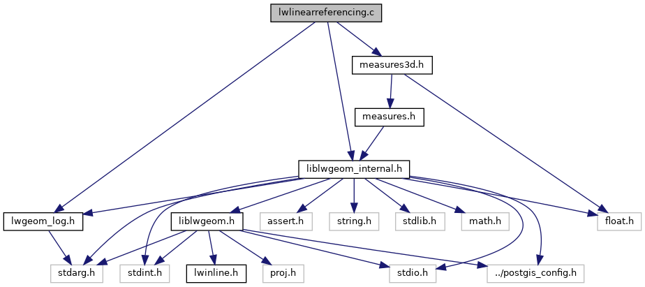
Include dependency graph for lwlinearreferencing.c:

Go to the source code of this file.
Functions | |
| static int | segment_locate_along (const POINT4D *p1, const POINT4D *p2, double m, double offset, POINT4D *pn) |
| static POINTARRAY * | ptarray_locate_along (const POINTARRAY *pa, double m, double offset) |
| static LWMPOINT * | lwline_locate_along (const LWLINE *lwline, double m, double offset) |
| static LWMPOINT * | lwmline_locate_along (const LWMLINE *lwmline, double m, double offset) |
| static LWMPOINT * | lwpoint_locate_along (const LWPOINT *lwpoint, double m, __attribute__((__unused__)) double offset) |
| static LWMPOINT * | lwmpoint_locate_along (const LWMPOINT *lwin, double m, __attribute__((__unused__)) double offset) |
| LWGEOM * | lwgeom_locate_along (const LWGEOM *lwin, double m, double offset) |
| Determine the location(s) along a measured line where m occurs and return as a multipoint. More... | |
| double | lwpoint_get_ordinate (const POINT4D *p, char ordinate) |
| Given a POINT4D and an ordinate number, return the value of the ordinate. More... | |
| void | lwpoint_set_ordinate (POINT4D *p, char ordinate, double value) |
| Given a point, ordinate number and value, set that ordinate on the point. More... | |
| int | point_interpolate (const POINT4D *p1, const POINT4D *p2, POINT4D *p, int hasz, int hasm, char ordinate, double interpolation_value) |
| Given two points, a dimensionality, an ordinate, and an interpolation value generate a new point that is proportionally between the input points, using the values in the provided dimension as the scaling factors. More... | |
| static LWCOLLECTION * | lwpoint_clip_to_ordinate_range (const LWPOINT *point, char ordinate, double from, double to) |
| Clip an input POINT between two values, on any ordinate input. More... | |
| static LWCOLLECTION * | lwmpoint_clip_to_ordinate_range (const LWMPOINT *mpoint, char ordinate, double from, double to) |
| Clip an input MULTIPOINT between two values, on any ordinate input. More... | |
| static POINTARRAY * | ptarray_clamp_to_ordinate_range (const POINTARRAY *ipa, char ordinate, double from, double to, uint8_t is_closed) |
| static LWCOLLECTION * | lwline_clip_to_ordinate_range (const LWLINE *line, char ordinate, double from, double to) |
| Take in a LINESTRING and return a MULTILINESTRING of those portions of the LINESTRING between the from/to range for the specified ordinate (XYZM) More... | |
| static LWCOLLECTION * | lwpoly_clip_to_ordinate_range (const LWPOLY *poly, char ordinate, double from, double to) |
| Clip an input LWPOLY between two values, on any ordinate input. More... | |
| static LWCOLLECTION * | lwtriangle_clip_to_ordinate_range (const LWTRIANGLE *tri, char ordinate, double from, double to) |
| Clip an input LWTRIANGLE between two values, on any ordinate input. More... | |
| static LWCOLLECTION * | lwcollection_clip_to_ordinate_range (const LWCOLLECTION *icol, char ordinate, double from, double to) |
| Clip an input COLLECTION between two values, on any ordinate input. More... | |
| LWCOLLECTION * | lwgeom_clip_to_ordinate_range (const LWGEOM *lwin, char ordinate, double from, double to, double offset) |
| Given a geometry clip based on the from/to range of one of its ordinates (x, y, z, m). More... | |
| LWCOLLECTION * | lwgeom_locate_between (const LWGEOM *lwin, double from, double to, double offset) |
| Determine the segments along a measured line that fall within the m-range given. More... | |
| double | lwgeom_interpolate_point (const LWGEOM *lwin, const LWPOINT *lwpt) |
| Find the measure value at the location on the line closest to the point. More... | |
| static double | segments_tcpa (POINT4D *p0, const POINT4D *p1, POINT4D *q0, const POINT4D *q1, double t0, double t1) |
| static int | ptarray_collect_mvals (const POINTARRAY *pa, double tmin, double tmax, double *mvals) |
| static int | compare_double (const void *pa, const void *pb) |
| static int | uniq (double *vals, int nvals) |
| static int | ptarray_locate_along_linear (const POINTARRAY *pa, double m, POINT4D *p, uint32_t from) |
| double | lwgeom_tcpa (const LWGEOM *g1, const LWGEOM *g2, double *mindist) |
| Find the time of closest point of approach. More... | |
| int | lwgeom_cpa_within (const LWGEOM *g1, const LWGEOM *g2, double maxdist) |
| Is the closest point of approach within a distance ? More... | |