Loading...
Searching...
No Matches
◆ circ_node_internal_new()
Create a new internal node, calculating the new measure range for the node, and storing pointers to the child nodes.
Definition at line 231 of file lwgeodetic_tree.c.
232{
233 CIRC_NODE *node = NULL;
234 GEOGRAPHIC_POINT new_center, c1;
235 double new_radius;
236 double offset1, dist, D, r1, ri;
237 uint32_t i, new_geom_type;
238
240
241 /* Can't do anything w/ empty input */
242 if ( num_nodes < 1 )
243 return node;
244
245 /* Initialize calculation with values of the first circle */
246 new_center = c[0]->center;
247 new_radius = c[0]->radius;
248 new_geom_type = c[0]->geom_type;
249
250 /* Merge each remaining circle into the new circle */
251 for ( i = 1; i < num_nodes; i++ )
252 {
253 c1 = new_center;
254 r1 = new_radius;
255
256 dist = sphere_distance(&c1, &(c[i]->center));
257 ri = c[i]->radius;
258
259 /* Promote geometry types up the tree, getting more and more collected */
260 /* Go until we find a value */
261 if ( ! new_geom_type )
262 {
263 new_geom_type = c[i]->geom_type;
264 }
265 /* Promote singleton to a multi-type */
267 {
268 /* Anonymous collection if types differ */
269 if ( new_geom_type != c[i]->geom_type )
270 {
271 new_geom_type = COLLECTIONTYPE;
272 }
273 else
274 {
275 new_geom_type = lwtype_get_collectiontype(new_geom_type);
276 }
277 }
278 /* If we can't add next feature to this collection cleanly, promote again to anonymous collection */
280 {
281 new_geom_type = COLLECTIONTYPE;
282 }
283
284
285 LWDEBUGF(3, "distance between new (%g %g) and %i (%g %g) is %g", c1.lon, c1.lat, i, c[i]->center.lon, c[i]->center.lat, dist);
286
288 {
290 new_radius = r1 + 2*dist;
291 new_center = c1;
292 }
293 else if ( dist < fabs(r1 - ri) )
294 {
295 /* new contains next */
296 if ( r1 > ri )
297 {
299 new_center = c1;
300 new_radius = r1;
301 }
302 /* next contains new */
303 else
304 {
306 new_center = c[i]->center;
307 new_radius = ri;
308 }
309 }
310 else
311 {
313 /* New circle diameter */
314 D = dist + r1 + ri;
316
317 /* New radius */
318 new_radius = D / 2.0;
319
320 /* Distance from cn1 center to the new center */
321 offset1 = ri + (D - (2.0*r1 + 2.0*ri)) / 2.0;
323
324 /* Sometimes the sphere_direction function fails... this causes the center calculation */
325 /* to fail too. In that case, we're going to fall back to a cartesian calculation, which */
326 /* is less exact, so we also have to pad the radius by (hack alert) an arbitrary amount */
327 /* which is hopefully always big enough to contain the input edges */
329 {
330 circ_center_cartesian(&c1, &(c[i]->center), dist, offset1, &new_center);
331 new_radius *= 1.1;
332 }
333 }
334 LWDEBUGF(3, " new center is (%g %g) new radius is %g", new_center.lon, new_center.lat, new_radius);
335 }
336
338 node->p1 = NULL;
339 node->p2 = NULL;
340 node->center = new_center;
341 node->radius = new_radius;
342 node->num_nodes = num_nodes;
343 node->nodes = c;
344 node->edge_num = -1;
345 node->geom_type = new_geom_type;
348 return node;
349}
uint32_t lwtype_get_collectiontype(uint8_t type)
Given an lwtype number, what homogeneous collection can hold it?
Definition lwgeom.c:1114
int lwtype_is_collection(uint8_t type)
Determine whether a type number is a collection or not.
Definition lwgeom.c:1087
double sphere_distance(const GEOGRAPHIC_POINT *s, const GEOGRAPHIC_POINT *e)
Given two points on a unit sphere, calculate their distance apart in radians.
Definition lwgeodetic.c:948
static int circ_center_spherical(const GEOGRAPHIC_POINT *c1, const GEOGRAPHIC_POINT *c2, double distance, double offset, GEOGRAPHIC_POINT *center)
Given the centers of two circles, and the offset distance we want to put the new center between them ...
Definition lwgeodetic_tree.c:167
static int circ_center_cartesian(const GEOGRAPHIC_POINT *c1, const GEOGRAPHIC_POINT *c2, double distance, double offset, GEOGRAPHIC_POINT *center)
Where the circ_center_spherical() function fails, we need a fall-back.
Definition lwgeodetic_tree.c:192
Note that p1 and p2 are pointers into an independent POINTARRAY, do not free them.
Definition lwgeodetic_tree.h:37
References circ_node::center, circ_center_cartesian(), circ_center_spherical(), COLLECTIONTYPE, circ_node::edge_num, FP_EQUALS, circ_node::geom_type, GEOGRAPHIC_POINT::lat, GEOGRAPHIC_POINT::lon, LW_FAILURE, lwalloc(), LWDEBUG, LWDEBUGF, lwtype_get_collectiontype(), lwtype_is_collection(), circ_node::nodes, circ_node::num_nodes, circ_node::p1, circ_node::p2, circ_node::pt_outside, circ_node::radius, sphere_distance(), POINT2D::x, and POINT2D::y.
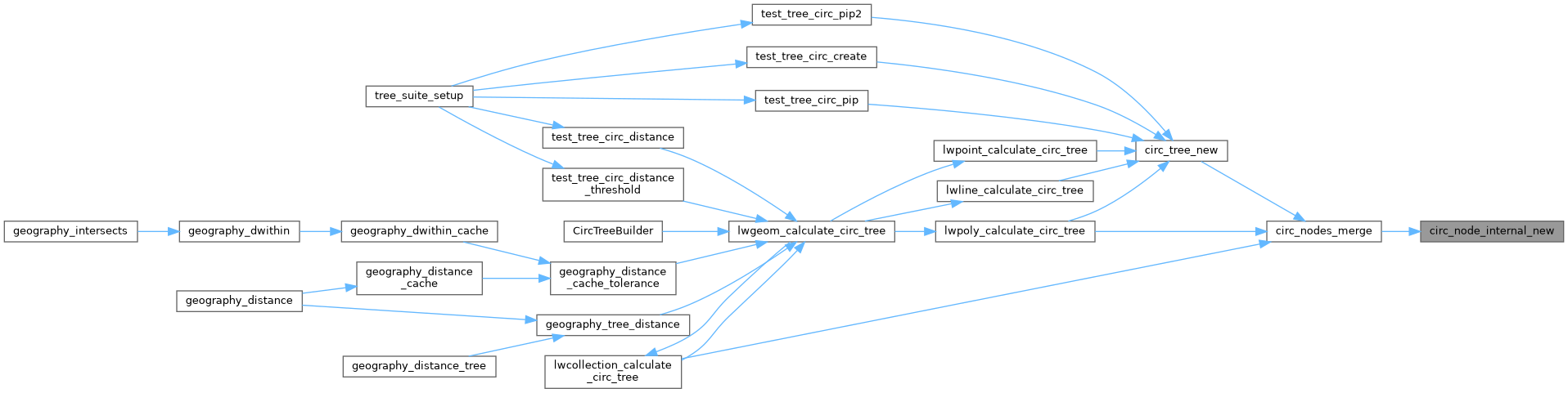
Referenced by circ_nodes_merge().
Here is the call graph for this function:
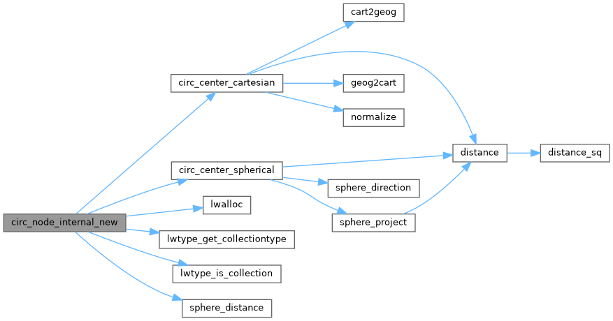
Here is the caller graph for this function: