Loading...
Searching...
No Matches
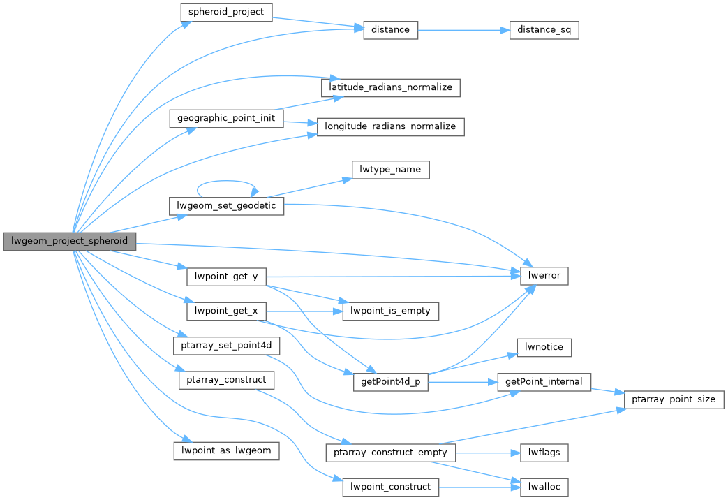
◆ lwgeom_project_spheroid()
|
extern |
Calculate the location of a point on a spheroid, give a start point, bearing and distance.
Calculate the location of a point on a spheroid, give a start point, bearing and distance.
- Parameters
-
r - location of first point. spheroid - spheroid definition. distance - distance, in units of the spheroid def'n. azimuth - azimuth in radians.
- Returns
- s - location of projected point.
Definition at line 2099 of file lwgeodetic.c.
2100{
2101 GEOGRAPHIC_POINT geo_source, geo_dest;
2102 POINT4D pt_dest;
2104 POINTARRAY *pa;
2105 LWPOINT *lwp;
2106
2107 /* Normalize distance to be positive*/
2110 azimuth += M_PI;
2111 }
2112
2113 /* Normalize azimuth */
2114 azimuth -= 2.0 * M_PI * floor(azimuth / (2.0 * M_PI));
2115
2116 /* Check the distance validity */
2118 {
2120 return NULL;
2121 }
2122
2123 /* Convert to ta geodetic point */
2126 geographic_point_init(x, y, &geo_source);
2127
2128 /* Try the projection */
2130 {
2131 LWDEBUGF(3, "Unable to project from (%g %g) with azimuth %g and distance %g", x, y, azimuth, distance);
2132 lwerror("Unable to project from (%g %g) with azimuth %g and distance %g", x, y, azimuth, distance);
2133 return NULL;
2134 }
2135
2136 /* Build the output LWPOINT */
2137 pa = ptarray_construct(0, 0, 1);
2141 ptarray_set_point4d(pa, 0, &pt_dest);
2144 return lwp;
2145}
void lwgeom_set_geodetic(LWGEOM *geom, int value)
Set the FLAGS geodetic bit on geometry an all sub-geometries and pointlists.
Definition lwgeom.c:946
LWPOINT * lwpoint_construct(int32_t srid, GBOX *bbox, POINTARRAY *point)
Definition lwpoint.c:129
void ptarray_set_point4d(POINTARRAY *pa, uint32_t n, const POINT4D *p4d)
Definition lwgeom_api.c:376
POINTARRAY * ptarray_construct(char hasz, char hasm, uint32_t npoints)
Construct an empty pointarray, allocating storage and setting the npoints, but not filling in any inf...
Definition ptarray.c:51
double longitude_radians_normalize(double lon)
Convert a longitude to the range of -PI,PI.
Definition lwgeodetic.c:50
double latitude_radians_normalize(double lat)
Convert a latitude to the range of -PI/2,PI/2.
Definition lwgeodetic.c:78
void geographic_point_init(double lon, double lat, GEOGRAPHIC_POINT *g)
Initialize a geographic point.
Definition lwgeodetic.c:180
int spheroid_project(const GEOGRAPHIC_POINT *r, const SPHEROID *spheroid, double distance, double azimuth, GEOGRAPHIC_POINT *g)
Given a location, an azimuth and a distance, computes the location of the projected point.
Definition lwspheroid.c:128
Definition liblwgeom.h:455
Definition liblwgeom.h:399
Definition liblwgeom.h:412
References distance(), geographic_point_init(), GEOGRAPHIC_POINT::lat, latitude_radians_normalize(), GEOGRAPHIC_POINT::lon, longitude_radians_normalize(), LW_FAILURE, LW_TRUE, LWDEBUGF, lwerror(), lwgeom_set_geodetic(), lwpoint_as_lwgeom(), lwpoint_construct(), lwpoint_get_x(), lwpoint_get_y(), POINT4D::m, ptarray_construct(), ptarray_set_point4d(), r, rad2deg, SPHEROID::radius, spheroid_project(), POINT4D::x, POINT4D::y, and POINT4D::z.
Referenced by geography_project().
Here is the call graph for this function:
Here is the caller graph for this function:
