PostGIS  3.0.6dev-r@@SVN_REVISION@@

◆ lwgeom_subdivide_recursive()

static void lwgeom_subdivide_recursive ( const LWGEOM geom,
uint8_t  dimension,
uint32_t  maxvertices,
uint32_t  depth,
LWCOLLECTION col 
)
static

Definition at line 2261 of file lwgeom.c.

2266 {
2267  const uint32_t maxdepth = 50;
2268 
2269  if (!geom)
2270  return;
2271 
2272  const GBOX *box_in = lwgeom_get_bbox(geom);
2273  if (!box_in)
2274  return;
2275 
2276  GBOX clip;
2277  gbox_duplicate(box_in, &clip);
2278  double width = clip.xmax - clip.xmin;
2279  double height = clip.ymax - clip.ymin;
2280 
2281  if ( geom->type == POLYHEDRALSURFACETYPE || geom->type == TINTYPE )
2282  lwerror("%s: unsupported geometry type '%s'", __func__, lwtype_name(geom->type));
2283 
2284  if ( width == 0.0 && height == 0.0 )
2285  {
2286  if ( geom->type == POINTTYPE && dimension == 0)
2288  return;
2289  }
2290 
2291  if (width == 0.0)
2292  {
2293  clip.xmax += FP_TOLERANCE;
2294  clip.xmin -= FP_TOLERANCE;
2295  width = 2 * FP_TOLERANCE;
2296  }
2297  if (height == 0.0)
2298  {
2299  clip.ymax += FP_TOLERANCE;
2300  clip.ymin -= FP_TOLERANCE;
2301  height = 2 * FP_TOLERANCE;
2302  }
2303 
2304  /* Always just recurse into collections */
2305  if ( lwgeom_is_collection(geom) && geom->type != MULTIPOINTTYPE )
2306  {
2307  LWCOLLECTION *incol = (LWCOLLECTION*)geom;
2308  /* Don't increment depth yet, since we aren't actually
2309  * subdividing geometries yet */
2310  for (uint32_t i = 0; i < incol->ngeoms; i++ )
2311  lwgeom_subdivide_recursive(incol->geoms[i], dimension, maxvertices, depth, col);
2312  return;
2313  }
2314 
2315  if (lwgeom_dimension(geom) < dimension)
2316  {
2317  /* We've hit a lower dimension object produced by clipping at
2318  * a shallower recursion level. Ignore it. */
2319  return;
2320  }
2321 
2322  /* But don't go too far. 2^50 ~= 10^15, that's enough subdivision */
2323  /* Just add what's left */
2324  if ( depth > maxdepth )
2325  {
2327  return;
2328  }
2329 
2330  uint32_t nvertices = lwgeom_count_vertices(geom);
2331 
2332  /* Skip empties entirely */
2333  if (nvertices == 0)
2334  return;
2335 
2336  /* If it is under the vertex tolerance, just add it, we're done */
2337  if (nvertices <= maxvertices)
2338  {
2340  return;
2341  }
2342 
2343  uint8_t split_ordinate = (width > height) ? 0 : 1;
2344  double center = (split_ordinate == 0) ? (clip.xmin + clip.xmax) / 2 : (clip.ymin + clip.ymax) / 2;
2345  double pivot = DBL_MAX;
2346  if (geom->type == POLYGONTYPE)
2347  {
2348  uint32_t ring_to_trim = 0;
2349  double ring_area = 0;
2350  double pivot_eps = DBL_MAX;
2351  double pt_eps = DBL_MAX;
2352  POINTARRAY *pa;
2353  LWPOLY *lwpoly = (LWPOLY *)geom;
2354 
2355  /* if there are more points in holes than in outer ring */
2356  if (nvertices >= 2 * lwpoly->rings[0]->npoints)
2357  {
2358  /* trim holes starting from biggest */
2359  for (uint32_t i = 1; i < lwpoly->nrings; i++)
2360  {
2361  double current_ring_area = fabs(ptarray_signed_area(lwpoly->rings[i]));
2362  if (current_ring_area >= ring_area)
2363  {
2364  ring_area = current_ring_area;
2365  ring_to_trim = i;
2366  }
2367  }
2368  }
2369 
2370  pa = lwpoly->rings[ring_to_trim];
2371 
2372  /* find most central point in chosen ring */
2373  for (uint32_t i = 0; i < pa->npoints; i++)
2374  {
2375  double pt;
2376  if (split_ordinate == 0)
2377  pt = getPoint2d_cp(pa, i)->x;
2378  else
2379  pt = getPoint2d_cp(pa, i)->y;
2380  pt_eps = fabs(pt - center);
2381  if (pivot_eps > pt_eps)
2382  {
2383  pivot = pt;
2384  pivot_eps = pt_eps;
2385  }
2386  }
2387  }
2388  GBOX subbox1, subbox2;
2389  gbox_duplicate(&clip, &subbox1);
2390  gbox_duplicate(&clip, &subbox2);
2391 
2392  if (pivot == DBL_MAX)
2393  pivot = center;
2394 
2395  if (split_ordinate == 0)
2396  {
2397  if (FP_NEQUALS(subbox1.xmax, pivot) && FP_NEQUALS(subbox1.xmin, pivot))
2398  subbox1.xmax = subbox2.xmin = pivot;
2399  else
2400  subbox1.xmax = subbox2.xmin = center;
2401  }
2402  else
2403  {
2404  if (FP_NEQUALS(subbox1.ymax, pivot) && FP_NEQUALS(subbox1.ymin, pivot))
2405  subbox1.ymax = subbox2.ymin = pivot;
2406  else
2407  subbox1.ymax = subbox2.ymin = center;
2408  }
2409 
2410  ++depth;
2411 
2412  {
2414  geom->srid, subbox1.xmin, subbox1.ymin, subbox1.xmax, subbox1.ymax);
2415  LWGEOM *clipped = lwgeom_intersection(geom, subbox);
2416  lwgeom_simplify_in_place(clipped, 0.0, LW_TRUE);
2417  lwgeom_free(subbox);
2418  if (clipped && !lwgeom_is_empty(clipped))
2419  {
2420  lwgeom_subdivide_recursive(clipped, dimension, maxvertices, depth, col);
2421  lwgeom_free(clipped);
2422  }
2423  }
2424  {
2426  geom->srid, subbox2.xmin, subbox2.ymin, subbox2.xmax, subbox2.ymax);
2427  LWGEOM *clipped = lwgeom_intersection(geom, subbox);
2428  lwgeom_simplify_in_place(clipped, 0.0, LW_TRUE);
2429  lwgeom_free(subbox);
2430  if (clipped && !lwgeom_is_empty(clipped))
2431  {
2432  lwgeom_subdivide_recursive(clipped, dimension, maxvertices, depth, col);
2433  lwgeom_free(clipped);
2434  }
2435  }
2436 }
void gbox_duplicate(const GBOX *original, GBOX *duplicate)
Copy the values of original GBOX into duplicate.
Definition: gbox.c:433
LWGEOM * lwgeom_intersection(const LWGEOM *geom1, const LWGEOM *geom2)
#define MULTIPOINTTYPE
Definition: liblwgeom.h:119
#define POINTTYPE
LWTYPE numbers, used internally by PostGIS.
Definition: liblwgeom.h:116
#define TINTYPE
Definition: liblwgeom.h:130
LWPOLY * lwpoly_construct_envelope(int32_t srid, double x1, double y1, double x2, double y2)
Definition: lwpoly.c:98
#define POLYGONTYPE
Definition: liblwgeom.h:118
#define POLYHEDRALSURFACETYPE
Definition: liblwgeom.h:128
const char * lwtype_name(uint8_t type)
Return the type name string associated with a type number (e.g.
Definition: lwutil.c:216
LWCOLLECTION * lwcollection_add_lwgeom(LWCOLLECTION *col, const LWGEOM *geom)
Appends geom to the collection managed by col.
Definition: lwcollection.c:188
#define LW_TRUE
Return types for functions with status returns.
Definition: liblwgeom.h:107
double ptarray_signed_area(const POINTARRAY *pa)
Returns the area in cartesian units.
Definition: ptarray.c:995
#define FP_TOLERANCE
Floating point comparators.
#define FP_NEQUALS(A, B)
int lwgeom_is_collection(const LWGEOM *geom)
Determine whether a LWGEOM can contain sub-geometries or not.
Definition: lwgeom.c:1079
LWGEOM * lwgeom_clone_deep(const LWGEOM *lwgeom)
Deep-clone an LWGEOM object.
Definition: lwgeom.c:511
uint32_t lwgeom_count_vertices(const LWGEOM *geom)
Count points in an LWGEOM.
Definition: lwgeom.c:1229
int lwgeom_dimension(const LWGEOM *geom)
For an LWGEOM, returns 0 for points, 1 for lines, 2 for polygons, 3 for volume, and the max dimension...
Definition: lwgeom.c:1281
const GBOX * lwgeom_get_bbox(const LWGEOM *lwg)
Get a non-empty geometry bounding box, computing and caching it if not already there.
Definition: lwgeom.c:725
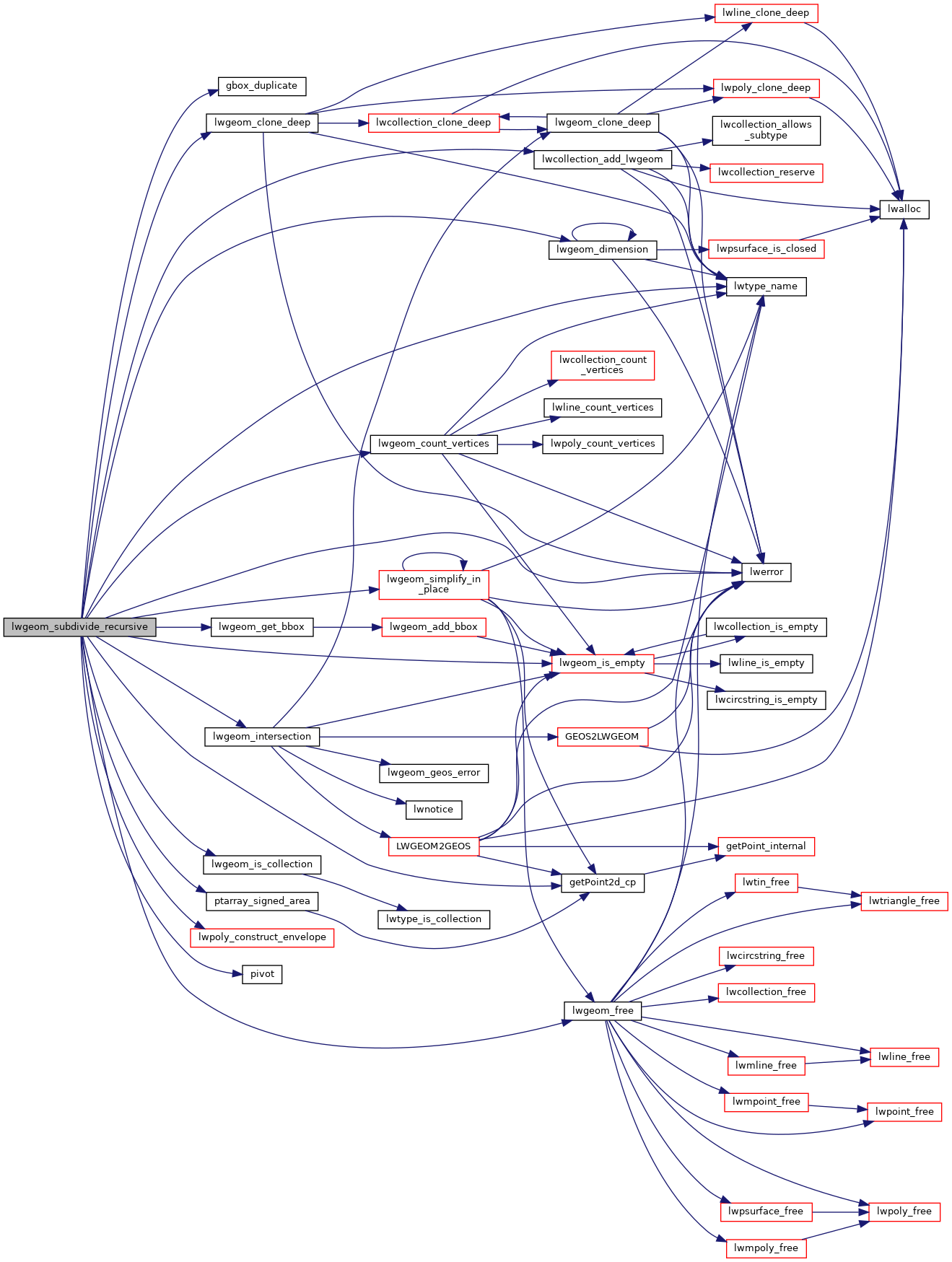
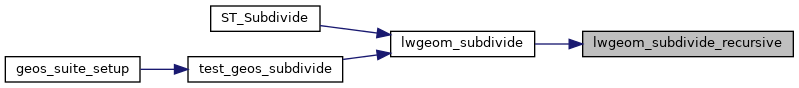
static void lwgeom_subdivide_recursive(const LWGEOM *geom, uint8_t dimension, uint32_t maxvertices, uint32_t depth, LWCOLLECTION *col)
Definition: lwgeom.c:2261
void lwgeom_free(LWGEOM *lwgeom)
Definition: lwgeom.c:1138
int lwgeom_simplify_in_place(LWGEOM *geom, double epsilon, int preserve_collapsed)
Definition: lwgeom.c:1715
void lwerror(const char *fmt,...)
Write a notice out to the error handler.
Definition: lwutil.c:190
static const POINT2D * getPoint2d_cp(const POINTARRAY *pa, uint32_t n)
Returns a POINT2D pointer into the POINTARRAY serialized_ptlist, suitable for reading from.
Definition: lwinline.h:91
static int lwgeom_is_empty(const LWGEOM *geom)
Return true or false depending on whether a geometry is an "empty" geometry (no vertices members)
Definition: lwinline.h:193
static double pivot(double *left, double *right)
Definition: rt_statistics.c:40
double ymax
Definition: liblwgeom.h:343
double xmax
Definition: liblwgeom.h:341
double ymin
Definition: liblwgeom.h:342
double xmin
Definition: liblwgeom.h:340
uint32_t ngeoms
Definition: liblwgeom.h:566
LWGEOM ** geoms
Definition: liblwgeom.h:561
uint8_t type
Definition: liblwgeom.h:448
int32_t srid
Definition: liblwgeom.h:446
POINTARRAY ** rings
Definition: liblwgeom.h:505
uint32_t nrings
Definition: liblwgeom.h:510
double y
Definition: liblwgeom.h:376
double x
Definition: liblwgeom.h:376
uint32_t npoints
Definition: liblwgeom.h:413

References FP_NEQUALS, FP_TOLERANCE, gbox_duplicate(), LWCOLLECTION::geoms, getPoint2d_cp(), LW_TRUE, lwcollection_add_lwgeom(), lwerror(), lwgeom_clone_deep(), lwgeom_count_vertices(), lwgeom_dimension(), lwgeom_free(), lwgeom_get_bbox(), lwgeom_intersection(), lwgeom_is_collection(), lwgeom_is_empty(), lwgeom_simplify_in_place(), lwpoly_construct_envelope(), lwtype_name(), MULTIPOINTTYPE, LWCOLLECTION::ngeoms, POINTARRAY::npoints, LWPOLY::nrings, pivot(), POINTTYPE, POLYGONTYPE, POLYHEDRALSURFACETYPE, ptarray_signed_area(), LWPOLY::rings, LWGEOM::srid, TINTYPE, LWGEOM::type, POINT2D::x, GBOX::xmax, GBOX::xmin, POINT2D::y, GBOX::ymax, and GBOX::ymin.

Referenced by lwgeom_subdivide().

Here is the call graph for this function:
Here is the caller graph for this function: