6. Acerca de los datos
Los datos para este taller constan de cuatro shapefiles de la ciudad de Nueva York y una tabla de atributos de variables sociodemográficas. Hemos cargado los shapefiles como tablas de PostGIS y los datos sociodemográficos se añadirán más tarde durante el taller.
A continuación se describe el número de registros y la tabla de atributos para cada uno de los conjuntos de datos. Estos valores de atributos y relaciones son fundamentales para nuestros análisis posteriores.
Para explorar la naturaleza de las tablas en pgAdmin, botón derecho en una tabla resaltada y seleccionar Propiedades. Aparecerá un resumen de las propiedades de la tabla, incluyendo una lista de los atriburos de la tabla dentro de la pestaña Columnas.
6.1. nyc_census_blocks
Una manzana censal es el área geográfica más pequeña de la que se tienen datos censales. Todas las geografías censales de nivel superior (grupos de manzanas, secciones, áreas metropolitanas, condados, etc.) pueden construirse a partir de uniones de manzanas censales. Hemos adjuntado algunos datos demográficos a nuestra colección de manzanas.
Número de registros: 38794
blkid |
Un código de 15 dígitos que identifica de forma única cada bloque del censo. Ej: 360050001009000 |
popn_total |
Número total de personas en el bloque del censo |
popn_white |
Número de personas que se auto-identifican como «Blanco/a» |
popn_black |
Número de personas que se auto-identifican con «Negro/a» |
popn_nativ |
Número de personas que se auto-identifican como «Nativo/a Americano/a» |
popn_asian |
Número de personas que se auto-identifican como «Asiático/a» |
popn_other |
Número de personas que se auto-identifican como otras categorías |
boroname |
Nombre del distrito de Nueva York, Manhattan, el Bronx, Brooklyn, Staten Island, Queens |
geom |
Límite del bloque |
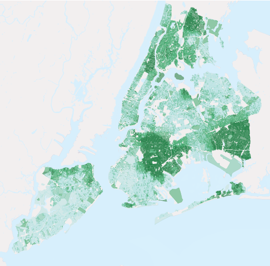
Población negra como porcentaje de la Población Total
Nota
Para introducir los datos del censo dentro del SIG, hay que unir dos piezas de información: los datos reales (texto) y los archivos de limites (espacial). Hay muchas formas para conseguir estos datos, incluyendo descargar ambos desde Census Bureau’s American FactFinder.
6.2. nyc_neighborhoods
Nueva York tiene una rica historia sobre los nombres y extensiones de sus barrios. Los barrios son constructos sociales que no siguen las lineas puestas por el gobierno. Por ejemplo, los barrios de Brooklyn de Carroll Gardens, Red Hook, y Cobble Hill se conocieron en cierto momento colectivamente como «Brooklyn Sur». Y ahora, en función del agente inmobiliario con el que se hable, los mismos cuatro bloques del barrio antes conocido como Red Hook ¡pueden ser Columbia Heights, Carroll Gardens West, o Red Hook!
Número de registros: 129
name |
Nombre del barrio |
boroname |
Nombre del distrito de Nueva York, Manhattan, el Bronx, Brooklyn, Staten Island, Queens |
geom |
Polígono de límite del barrio |
Los barrios de Nueva York
6.3. nyc_streets
Las líneas centrales de las calles forman la red de transporte de la ciudad. Estas calles se han marcado con tipos para distinguir entre vías como callejones, calles arteriales, autopistas y calles más pequeñas. Las zonas deseables para vivir pueden estar en calles residenciales y no junto a una autopista.
Número de registros: 19091
name |
Nombre de la calle |
Un solo sentido |
¿La calle es de sentido único? «Yes» = sí, «» = no |
tipo |
Tipo de carretera (primaria, secundaria, residencial, autopista) |
geom |
Línea central lineal de la calle |
Las calles de Nueva York. Las carreteras principales están en rojo.
6.4. nyc_subway_stations
Las estaciones de metro conectan a la superficie donde vive la gente con la red invisible de subterráneos que hay debajo. Como portales del sistema de transporte público, la ubicación de las estaciones ayuda a determinar la facilidad con que distintas personas acceden al sistema de metro.
Número de registros: 491
name |
Nombre de la estación |
borough (distrito) |
Nombre del distrito de Nueva York, Manhattan, el Bronx, Brooklyn, Staten Island, Queens |
routes (rutas) |
Líneas de metro que pasan por esta estación |
transfers (transbordos) |
Líneas a las que puede hacer transbordo a través de esta estación |
**express**(expreso) |
Estaciones donde paran trenes exprés, «express» = sí, «» = no |
geom |
Localización puntual de la estación |
Localización de las estaciones de metro de Nueva York
6.5. nyc_census_sociodata
Existe una rica colección de datos socio-económicos recopilados durante el censo, pero sólo a nivel geográfico más amplio de sección censal. Las manzanas censales se combinan para formar secciones censales (grupos de manzanas). Hemos recopilado algunos datos socio-económicos a nivel de sección censal para responder a algunas de las preguntas más interesantes sobre la ciudad de Nueva York.
Nota
El nyc_census_sociodata es una tabla de datos. Tendremos que conectarla a las geografías del Censo antes de realizar cualquier análisis espacial.
tractid (Id de la zona censal) |
Un código de 11 dígitos que identifica unívocamente cada conjunto censal. («36005000100») |
transit_total (tránsito total) |
Número de trabajadores en la zona censal |
transit_private (tránsito privado) |
Número de trabajadores de la zona que utilizan automóviles privados / motocicletas |
transit_public (tránsito público) |
Número de trabajadores de la zona que utilizan el transporte público |
transit_walk (tránsito peatonal) |
Número de trabajadores de la zona que van a pie |
transit_other (otros tipos de tránsito) |
Número de trabajadores en el tramo que utilizan otras formas como caminar / ir en bicicleta |
transit_none ( sin tránsito) |
Número de trabajadores de la zona que trabajan desde casa |
transit_time_mins |
Número total de minutos dedicados al transporte por todos los trabajadores en la zona censal (minutos) |
family_count |
Número de familias en la zona censal |
family_income_median (Media de ingresos por familia) |
Ingreso familiar mediano en la zona censal (dólares) |
family_income_mean |
Ingreso familiar promedio en la zona censal (dólares) |
family_income_aggregate |
Ingreso total de todas las familias en la zona censal (dólares) |
edu_total |
Número de personas con historial educativo |
edu_no_highschool_dipl |
Número de personas sin diploma de secundaria |
edu_highschool_dipl |
Número de personas con diploma de secundaria y sin educación posterior |
edu_college_dipl |
Número de personas con diploma universitario |
edu_graduate_dipl |
Número de personas con diploma de posgrado |
