名称
ST_MapAlgebraExpr — 2 栅格波段版本:通过对提供的两个输入栅格波段和像素类型应用有效的 PostgreSQL 代数运算来创建新的单波段栅格。 如果未指定波段编号,则假定每个栅格的波段 1。 生成的栅格将在第一个栅格定义的网格上对齐(比例、倾斜和像素角),并具有由“extenttype”参数定义的范围。 “extenttype”的值可以是:INTERSECTION、UNION、FIRST、SECOND。
大纲
raster ST_MapAlgebraExpr(raster rast1, raster rast2, text expression, text pixeltype=same_as_rast1_band, text extenttype=INTERSECTION, text nodata1expr=NULL, text nodata2expr=NULL, double precision nodatanodataval=NULL);
raster ST_MapAlgebraExpr(raster rast1, integer band1, raster rast2, integer band2, text expression, text pixeltype=same_as_rast1_band, text extenttype=INTERSECTION, text nodata1expr=NULL, text nodata2expr=NULL, double precision nodatanodataval=NULL);
Description
![[警告]](../images/warning.png)
|
|
|
ST_MapAlgebraExpr 自 2.1.0 起已弃用。 使用 ST_MapAlgebra (expression version)(表达式版本)代替。 |
通过对两个输入栅格波段 rast1, (rast2) 上的expression定义的两个波段应用有效的 PostgreSQL 代数运算,创建一个新的单波段栅格。 如果没有 band1,则指定 band2,则假定为 band 1。 生成的栅格将在第一个栅格定义的网格上对齐(比例、倾斜和像素角)。 生成的栅格将具有由extenttype 参数定义的范围。
-
expression -
涉及两个栅格的 PostgreSQL 代数表达式和 PostgreSQL 定义的函数/运算符,用于定义像素相交时的像素值。 例如 (([rast1] [rast2])/2.0)::integer
-
pixeltype -
输出栅格的结果像素类型。 必须是ST_BandPixelType 中列出的一项,可省略或设置为 NULL。 如果未传入或设置为 NULL,将默认为第一个栅格的像素类型。
-
extenttype -
控制生成的栅格的范围
-
INTERSECTION- 新栅格的范围是两个栅格的交集。 这是默认设置。 -
UNION- 新栅格的范围是两个栅格的并集。 -
FIRST- 新栅格的范围与第一个栅格的范围相同。 -
SECOND- 新栅格的范围与第二个栅格的范围相同。
-
-
nodata1expr -
仅涉及
rast2的代数表达式或定义当rast1的像素为无数据值并且空间对应的 rast2 像素具有值时返回的内容的常量。 -
nodata2expr -
仅涉及
rast1常量的代数表达式,该常量定义当rast2的像素为无数据值且空间对应的 rast1 像素具有值时返回的内容。 -
nodatanodataval -
当空间对应的 rast1 和 rast2 像素均为无数据值时要返回的数值常量。
如果传入pixeltype,则新栅格将具有该像素类型的波段。 如果将像素类型传递为 NULL 或未指定像素类型,则新的栅格波段将具有与输入 rast1 波段相同的像素类型。
使用术语 [rast1.val] [rast2.val] 指代原始栅格波段的像素值,使用 [rast1.x]、[rast1.y] 等指代像素的列/行位置。
可用性: 2.0.0
示例
2 Band Intersection and Union.
根据原始栅格创建一个新的 1 波段栅格,该栅格是原始栅格波段的模 2 的函数。
Create a cool set of rasters.
Insert some cool shapes around Boston in Massachusetts state plane meters, then map their intersection and union.
DROP TABLE IF EXISTS fun_shapes;
CREATE TABLE fun_shapes(rid serial PRIMARY KEY, fun_name text, rast raster);

INSERT INTO fun_shapes(fun_name, rast)
VALUES ('ref', ST_AsRaster(ST_MakeEnvelope(235229, 899970, 237229, 901930, 26986), 200, 200, '8BUI', 0, 0));

INSERT INTO fun_shapes(fun_name, rast)
WITH ref(rast) AS (SELECT rast FROM fun_shapes WHERE fun_name = 'ref' )
SELECT 'area' AS fun_name, ST_AsRaster(ST_Buffer(ST_SetSRID(ST_Point(236229, 900930), 26986), 1000),
            ref.rast, '8BUI', 10, 0) As rast
FROM ref
UNION ALL
SELECT 'rand bubbles',
       ST_AsRaster(
           (
               SELECT ST_Collect(geom)
               FROM (
                   SELECT ST_Buffer(
                       ST_SetSRID(ST_Point(236229 + i*random()*100, 900930 + j*random()*100), 26986),
                       random()*20
                   ) AS geom
                   FROM generate_series(1, 10) AS i,
                        generate_series(1, 10) AS j
               ) AS foo
           ),
           ref.rast, '8BUI', 200, 0
       )
FROM ref;

SELECT  ST_MapAlgebraExpr(area.rast, bub.rast, '[rast2.val]', '8BUI', 'INTERSECTION', '[rast2.val]', '[rast1.val]') As interrast,
        ST_MapAlgebraExpr(area.rast, bub.rast, '[rast2.val]', '8BUI', 'UNION', '[rast2.val]', '[rast1.val]') As unionrast
FROM
  (SELECT rast FROM fun_shapes WHERE fun_name = 'area') As area
CROSS JOIN
  (SELECT rast FROM fun_shapes WHERE fun_name = 'rand bubbles') As bub
The same intersection and union operations using two deterministic, self-contained rasters.
WITH canvas AS (
    SELECT ST_AddBand(
        ST_MakeEmptyRaster(80, 80, 0, 80, 1, -1, 0, 0, 0),
        1, '8BUI', 40, 0
    ) AS rast
), inputs AS (
    SELECT
        rast AS raster_1,
        ST_AsRaster(
            ST_Buffer(ST_Point(40, 40), 28),
            rast,
            '8BUI', 220, 0
        ) AS raster_2
    FROM canvas
), variants AS (
    SELECT 'raster 1' AS title, raster_1 AS rendered FROM inputs
    UNION ALL
    SELECT 'raster 2', raster_2 FROM inputs
    UNION ALL
    SELECT 'intersection', ST_MapAlgebraExpr(
        raster_1, raster_2,
        '[rast2.val]', '8BUI', 'INTERSECTION',
        '[rast2.val]', '[rast1.val]'
    ) FROM inputs
    UNION ALL
    SELECT 'union', ST_MapAlgebraExpr(
        raster_1, raster_2,
        '[rast2.val]', '8BUI', 'UNION',
        '[rast2.val]', '[rast1.val]'
    ) FROM inputs
)
SELECT title, ST_AsPNG(rendered) AS image
FROM variants
ORDER BY CASE title
    WHEN 'raster 1' THEN 1
    WHEN 'raster 2' THEN 2
    WHEN 'intersection' THEN 3
    ELSE 4
END;
title        | image
--------------+---------------------------
 raster 1     | PNG image, 80 x 80 pixels
 raster 2     | PNG image, 56 x 56 pixels
 intersection | PNG image, 56 x 56 pixels
 union        | PNG image, 80 x 80 pixels
Overlaying rasters on a one-unit-per-pixel canvas as separate bands. We use ST_AsPNG to render the image so all single band ones look grey.
WITH mygeoms AS (
    SELECT 2 AS bnum, ST_Buffer(ST_Point(1, 5), 10) AS geom
    UNION ALL
    SELECT 3,
        ST_Buffer(
            ST_GeomFromText('LINESTRING(50 50,150 150,150 50)'),
            10,
            'join=bevel'
        )
    UNION ALL
    SELECT 1,
        ST_Buffer(
            ST_GeomFromText('LINESTRING(60 50,150 150,150 50)'),
            5,
            'join=bevel'
        )
), canvas AS (
    SELECT ST_AddBand(
        ST_MakeEmptyRaster(
            200,
            200,
            ST_XMin(e)::integer,
            ST_YMax(e)::integer,
            1, -1, 0, 0),
        '8BUI'::text,
        0
    ) AS rast
    FROM (
      SELECT ST_Extent(geom) AS e
      FROM mygeoms
    ) AS bounds
), rbands AS (
    SELECT ARRAY(
        SELECT ST_MapAlgebraExpr(
            canvas.rast,
            ST_AsRaster(m.geom, canvas.rast, '8BUI', 100),
            '[rast2.val]', '8BUI', 'FIRST',
            '[rast2.val]', '[rast1.val]'
        )
        FROM mygeoms AS m
        CROSS JOIN canvas
        ORDER BY m.bnum
    ) AS rasts
)
SELECT title, ST_AsPNG(rendered) AS image
FROM rbands
CROSS JOIN LATERAL (VALUES
    ('band 1', rasts[1]),
    ('band 2', rasts[2]),
    ('band 3', rasts[3]),
    ('RGB', ST_AddBand(ST_AddBand(rasts[1], rasts[2]), rasts[3]))
) AS variants(title, rendered);
title  | image
--------+-----------------------------
 band 1 | PNG image, 200 x 200 pixels
 band 2 | PNG image, 200 x 200 pixels
 band 3 | PNG image, 200 x 200 pixels
 RGB    | PNG image, 200 x 200 pixels
Overlay a two-meter boundary of selected parcels over aerial imagery. The query first unions the parcel geometries, clips the source raster shards to the region, unions those smaller shards, and finally adds the first two bands plus a third-band map algebra overlay.
Create a new three-band raster composed of the first two clipped bands and the third band overlaid with the geometry. This query took 3.6 seconds on a 64-bit PostGIS Windows installation.
WITH pr AS (
    SELECT ST_Clip(rast, ST_Expand(geom, 50)) AS rast, g.geom
    FROM aerials.o_2_boston AS r
    INNER JOIN (
        SELECT ST_Union(ST_Transform(geom, 26986)) AS geom
        FROM landparcels
        WHERE pid IN ('0303890000', '0303900000')
    ) AS g
        ON ST_Intersects(rast::geometry, ST_Expand(g.geom, 50))
), prunion AS (
    SELECT ST_AddBand(
        NULL,
        ARRAY[
            ST_Union(rast, 1),
            ST_Union(rast, 2),
            ST_Union(rast, 3)
        ]
    ) AS clipped,
    geom
    FROM pr
    GROUP BY geom
)
SELECT ST_AddBand(
    ST_Band(clipped, ARRAY[1, 2]),
    ST_MapAlgebraExpr(
     ST_Band(clipped, 3),
     ST_AsRaster(ST_Buffer(ST_Boundary(geom), 2), clipped, '8BUI', 250),
     '[rast2.val]',
     '8BUI',
     'FIRST',
     '[rast2.val]',
     '[rast1.val]') ) As rast
FROM prunion;
Parcel-boundary overlay.
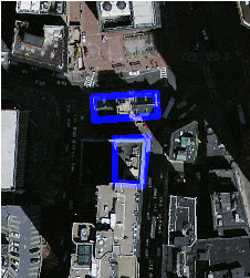
The blue lines are the boundaries of selected parcels |
The generated four-panel canvas example above shows the same band-overlay technique without requiring an external aerial-imagery or parcel table.