제목
ST_MapAlgebraExpr — 래스터 밴드 2개 버전: 입력 래스터 2개에 대해 유효한 PostgreSQL 대수 연산을 적용해서 형성되고, 설정한 픽셀 유형을 가진, 밴드 1개를 가진 새 래스터를 생성합니다. 따로 밴드를 설정하지 않을 경우, 각 래스터의 밴드 1로 가정합니다. 출력 래스터는 첫 번째 래스터가 정의하는 그리드 상에 (축척, 기울기 및 픽셀 모서리가) 정렬될 것입니다. extenttype 파라미터가 출력 래스터의 범위를 정의할 것입니다. extenttype 의 값은 INTERSECTION, UNION, FIRST, SECOND가 될 수 있습니다.
요약
raster ST_MapAlgebraExpr(raster rast1, raster rast2, text expression, text pixeltype=same_as_rast1_band, text extenttype=INTERSECTION, text nodata1expr=NULL, text nodata2expr=NULL, double precision nodatanodataval=NULL);
raster ST_MapAlgebraExpr(raster rast1, integer band1, raster rast2, integer band2, text expression, text pixeltype=same_as_rast1_band, text extenttype=INTERSECTION, text nodata1expr=NULL, text nodata2expr=NULL, double precision nodatanodataval=NULL);
Description
![[주의]](../images/warning.png)
|
|
|
ST_MapAlgebraExpr 2.1.0 버전부터 더 이상 이 함수를 지원하지 않습니다. 대신 ST_MapAlgebra (expression version) 함수를 이용하십시오. |
입력 래스터 밴드 rast1, (rast2)에 대한 expression 이 정의하는 밴드 2개에 대해, 유효한 PostgreSQL 대수 연산을 적용해서 형성된, 밴드 1개를 가진 새 래스터를 생성합니다. band1, band2 를 설정하지 않을 경우, 밴드 1로 가정합니다. 출력 래스터는 첫 번째 래스터가 정의하는 그리드 상에 (축척, 기울기 및 픽셀 모서리가) 정렬될 것입니다. extenttype 파라미터가 출력 래스터의 범위를 정의할 것입니다.
-
expression -
래스터 2개가 관련된 PostgreSQL 대수 표현식 및 픽셀들이 교차할 경우 픽셀 값을 정의할 PostgreSQL 정의 함수/연산자입니다. 예: (([rast1] + [rast2])/2.0)::integer
-
pixeltype -
출력 래스터의 픽셀 유형입니다. 이 유형은 ST_BandPixelType 목록에 존재하는 유형 가운데 하나이거나, 생략되거나, NULL로 설정돼야만 합니다. 따로 설정하지 않거나 NULL로 설정하지 않으면, 첫 번째 래스터의 픽셀 유형을 기본값으로 삼을 것입니다.
-
extenttype -
출력 래스터의 범위 제어
-
INTERSECTION- 새 래스터의 범위는 두 래스터의 교차 부분입니다. 기본값입니다. -
UNION- 새 래스터의 범위는 두 래스터를 통합한 범위입니다. -
FIRST- 새 래스터의 범위는 첫 번째 래스터의 범위와 동일합니다. -
SECOND- 새 래스터의 범위는 두 번째 래스터의 범위와 동일합니다.
-
-
nodata1expr -
rast1의 픽셀들이 NODATA 값이고 공간적으로 상응하는rast2의 픽셀들이 값을 가지고 있을 때 어떤 것을 반환할지 정의하는 상수만, 또는rast2와만 관련된 대수 표현식입니다. -
nodata2expr -
rast2의 픽셀들이 NODATA 값이고 공간적으로 상응하는rast1의 픽셀들이 값을 가지고 있을 때 어떤 것을 반환할지 정의하는 상수만, 또는rast1과만 관련된 대수 표현식입니다. -
nodatanodataval -
공간적으로 상응하는
rast1및rast2의 픽셀들이 모두 NODATA 값일 경우 반환하는 숫자 상수입니다.
pixeltype 을 설정할 경우, 새 래스터의 밴드가 해당 픽셀 유형이 될 것입니다. pixeltype 이 NULL이거나 따로 설정하지 않을 경우, 새 래스터의 밴드는 입력 rast1 의 밴드와 동일한 픽셀 유형이 될 것입니다.
원본 밴드의 픽셀 값을 참조하는 데 [rast1.val], [rast2.val], 픽셀의 열/행 위치를 참조하는 데 [rast1.x], [rast1.y] 등의 용어를 사용하십시오.
2.0.0 버전부터 사용할 수 있습니다.
예시
2 Band Intersection and Union.
원본 래스터 2개를 입력받는 모듈로(modulo) 함수인 원본으로부터 밴드 1개를 가진 새 래스터를 생성합니다.
Create a cool set of rasters.
Insert some cool shapes around Boston in Massachusetts state plane meters, then map their intersection and union.
DROP TABLE IF EXISTS fun_shapes;
CREATE TABLE fun_shapes(rid serial PRIMARY KEY, fun_name text, rast raster);

INSERT INTO fun_shapes(fun_name, rast)
VALUES ('ref', ST_AsRaster(ST_MakeEnvelope(235229, 899970, 237229, 901930, 26986), 200, 200, '8BUI', 0, 0));

INSERT INTO fun_shapes(fun_name, rast)
WITH ref(rast) AS (SELECT rast FROM fun_shapes WHERE fun_name = 'ref' )
SELECT 'area' AS fun_name, ST_AsRaster(ST_Buffer(ST_SetSRID(ST_Point(236229, 900930), 26986), 1000),
            ref.rast, '8BUI', 10, 0) As rast
FROM ref
UNION ALL
SELECT 'rand bubbles',
       ST_AsRaster(
           (
               SELECT ST_Collect(geom)
               FROM (
                   SELECT ST_Buffer(
                       ST_SetSRID(ST_Point(236229 + i*random()*100, 900930 + j*random()*100), 26986),
                       random()*20
                   ) AS geom
                   FROM generate_series(1, 10) AS i,
                        generate_series(1, 10) AS j
               ) AS foo
           ),
           ref.rast, '8BUI', 200, 0
       )
FROM ref;

SELECT  ST_MapAlgebraExpr(area.rast, bub.rast, '[rast2.val]', '8BUI', 'INTERSECTION', '[rast2.val]', '[rast1.val]') As interrast,
        ST_MapAlgebraExpr(area.rast, bub.rast, '[rast2.val]', '8BUI', 'UNION', '[rast2.val]', '[rast1.val]') As unionrast
FROM
  (SELECT rast FROM fun_shapes WHERE fun_name = 'area') As area
CROSS JOIN
  (SELECT rast FROM fun_shapes WHERE fun_name = 'rand bubbles') As bub
The same intersection and union operations using two deterministic, self-contained rasters.
WITH canvas AS (
    SELECT ST_AddBand(
        ST_MakeEmptyRaster(80, 80, 0, 80, 1, -1, 0, 0, 0),
        1, '8BUI', 40, 0
    ) AS rast
), inputs AS (
    SELECT
        rast AS raster_1,
        ST_AsRaster(
            ST_Buffer(ST_Point(40, 40), 28),
            rast,
            '8BUI', 220, 0
        ) AS raster_2
    FROM canvas
), variants AS (
    SELECT 'raster 1' AS title, raster_1 AS rendered FROM inputs
    UNION ALL
    SELECT 'raster 2', raster_2 FROM inputs
    UNION ALL
    SELECT 'intersection', ST_MapAlgebraExpr(
        raster_1, raster_2,
        '[rast2.val]', '8BUI', 'INTERSECTION',
        '[rast2.val]', '[rast1.val]'
    ) FROM inputs
    UNION ALL
    SELECT 'union', ST_MapAlgebraExpr(
        raster_1, raster_2,
        '[rast2.val]', '8BUI', 'UNION',
        '[rast2.val]', '[rast1.val]'
    ) FROM inputs
)
SELECT title, ST_AsPNG(rendered) AS image
FROM variants
ORDER BY CASE title
    WHEN 'raster 1' THEN 1
    WHEN 'raster 2' THEN 2
    WHEN 'intersection' THEN 3
    ELSE 4
END;
title        | image
--------------+---------------------------
 raster 1     | PNG image, 80 x 80 pixels
 raster 2     | PNG image, 56 x 56 pixels
 intersection | PNG image, 56 x 56 pixels
 union        | PNG image, 80 x 80 pixels
Overlaying rasters on a one-unit-per-pixel canvas as separate bands. We use ST_AsPNG to render the image so all single band ones look grey.
WITH mygeoms AS (
    SELECT 2 AS bnum, ST_Buffer(ST_Point(1, 5), 10) AS geom
    UNION ALL
    SELECT 3,
        ST_Buffer(
            ST_GeomFromText('LINESTRING(50 50,150 150,150 50)'),
            10,
            'join=bevel'
        )
    UNION ALL
    SELECT 1,
        ST_Buffer(
            ST_GeomFromText('LINESTRING(60 50,150 150,150 50)'),
            5,
            'join=bevel'
        )
), canvas AS (
    SELECT ST_AddBand(
        ST_MakeEmptyRaster(
            200,
            200,
            ST_XMin(e)::integer,
            ST_YMax(e)::integer,
            1, -1, 0, 0),
        '8BUI'::text,
        0
    ) AS rast
    FROM (
      SELECT ST_Extent(geom) AS e
      FROM mygeoms
    ) AS bounds
), rbands AS (
    SELECT ARRAY(
        SELECT ST_MapAlgebraExpr(
            canvas.rast,
            ST_AsRaster(m.geom, canvas.rast, '8BUI', 100),
            '[rast2.val]', '8BUI', 'FIRST',
            '[rast2.val]', '[rast1.val]'
        )
        FROM mygeoms AS m
        CROSS JOIN canvas
        ORDER BY m.bnum
    ) AS rasts
)
SELECT title, ST_AsPNG(rendered) AS image
FROM rbands
CROSS JOIN LATERAL (VALUES
    ('band 1', rasts[1]),
    ('band 2', rasts[2]),
    ('band 3', rasts[3]),
    ('RGB', ST_AddBand(ST_AddBand(rasts[1], rasts[2]), rasts[3]))
) AS variants(title, rendered);
title  | image
--------+-----------------------------
 band 1 | PNG image, 200 x 200 pixels
 band 2 | PNG image, 200 x 200 pixels
 band 3 | PNG image, 200 x 200 pixels
 RGB    | PNG image, 200 x 200 pixels
Overlay a two-meter boundary of selected parcels over aerial imagery. The query first unions the parcel geometries, clips the source raster shards to the region, unions those smaller shards, and finally adds the first two bands plus a third-band map algebra overlay.
Create a new three-band raster composed of the first two clipped bands and the third band overlaid with the geometry. This query took 3.6 seconds on a 64-bit PostGIS Windows installation.
WITH pr AS (
    SELECT ST_Clip(rast, ST_Expand(geom, 50)) AS rast, g.geom
    FROM aerials.o_2_boston AS r
    INNER JOIN (
        SELECT ST_Union(ST_Transform(geom, 26986)) AS geom
        FROM landparcels
        WHERE pid IN ('0303890000', '0303900000')
    ) AS g
        ON ST_Intersects(rast::geometry, ST_Expand(g.geom, 50))
), prunion AS (
    SELECT ST_AddBand(
        NULL,
        ARRAY[
            ST_Union(rast, 1),
            ST_Union(rast, 2),
            ST_Union(rast, 3)
        ]
    ) AS clipped,
    geom
    FROM pr
    GROUP BY geom
)
SELECT ST_AddBand(
    ST_Band(clipped, ARRAY[1, 2]),
    ST_MapAlgebraExpr(
     ST_Band(clipped, 3),
     ST_AsRaster(ST_Buffer(ST_Boundary(geom), 2), clipped, '8BUI', 250),
     '[rast2.val]',
     '8BUI',
     'FIRST',
     '[rast2.val]',
     '[rast1.val]') ) As rast
FROM prunion;
Parcel-boundary overlay.
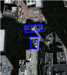
The blue lines are the boundaries of selected parcels |
The generated four-panel canvas example above shows the same band-overlay technique without requiring an external aerial-imagery or parcel table.