Name
ST_LocateBetween — Returns the portions of a geometry that match a measure range.
Synopsis
geometry ST_LocateBetween(geometry geom, float8 measure_start, float8 measure_end, float8 offset = 0);
설명
설정한 척도와 일치하는 요소들을 가진 파생 도형 집합의 값을 반환합니다. 폴리곤 구성 요소는 지원되지 않습니다.
오프셋을 설정할 경우, 그 결과 입력 라인에서 설정한 단위 개수만큼 왼쪽 또는 오른쪽에 오프셋 도형 집합을 출력할 것입니다. 양의 오프셋은 왼쪽, 음의 오프셋은 오른쪽으로 출력할 것입니다.
Clipping a non-convex POLYGON may produce invalid geometry.
The semantic is specified by the ISO/IEC 13249-3 SQL/MM Spatial standard.
1.1.0 버전부터 예전 명칭인 ST_Locate_Between_Measures로 사용할 수 있습니다.
변경 사항: 2.0.0 미만 버전에서는 ST_Locate_Along_Measure라는 명칭이었습니다. 예전 명칭은 더 지원되지 않고 곧 삭제될 예정이지만, 아직은 사용할 수 있습니다.
Enhanced: 3.0.0 - added support for POLYGON, TIN, TRIANGLE.
 This function supports M coordinates.
 This method implements the SQL/MM specification. SQL-MM IEC 13249-3: 5.1
예시
SELECT ST_AsText(
  ST_LocateBetween(
       'MULTILINESTRING M ((1 2 3, 3 4 2, 9 4 3),(1 2 3, 5 4 5))':: geometry,
       1.5, 3 ));
------------------------------------------------------------------------
 GEOMETRYCOLLECTION M (LINESTRING M (1 2 3,3 4 2,9 4 3),POINT M (1 2 3))

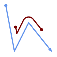
A LineString with the section between measures 2 and 8, offset to the left
SELECT ST_AsText( ST_LocateBetween(
  ST_AddMeasure('LINESTRING (20 180, 50 20, 100 120, 180 20)', 0, 10),
  2, 8,
  20
));
------------------------------------------------------------------------
MULTILINESTRING((54.49835019899045 104.53426957938231,58.70056060327303 82.12248075654186,69.16695286779743 103.05526528559065,82.11145618000168 128.94427190999915,84.24893681714357 132.32493442618113,87.01636951231555 135.21267035596549,90.30307285299679 137.49198684843182,93.97759758337769 139.07172433557758,97.89298381958797 139.8887023914453,101.89263860095893 139.9102465862721,105.81659870902816 139.13549527600819,109.50792827749828 137.5954340631298,112.81899532549731 135.351656550512,115.6173761888606 132.49390095108848,145.31017306064817 95.37790486135405))