Name
ST_Azimuth — Gibt die 2-dimenionale kürzeste Strecke zwischen zwei Geometrien als Linie zurück
Synopsis
float ST_Azimuth(geometry origin, geometry target);
float ST_Azimuth(geography origin, geography target);
Beschreibung
Returns the azimuth in radians of the target point from the origin point, or NULL if the two points are coincident. The azimuth angle is a positive clockwise angle referenced from the positive Y axis (geometry) or the North meridian (geography): North = 0; Northeast = π/4; East = π/2; Southeast = 3π/4; South = π; Southwest 5π/4; West = 3π/2; Northwest = 7π/4.
For the geography type, the azimuth solution is known as the inverse geodesic problem.
The azimuth is a mathematical concept defined as the angle between a reference vector and a point, with angular units in radians. The result value in radians can be converted to degrees using the PostgreSQL function degrees().
Der Azimut ist in Verbindung mit ST_Translate besonders nützlich, weil damit ein Objekt entlang seiner rechtwinkeligen Achse verschoben werden kann. Siehe dazu die Funktion "upgis_lineshift", in dem Abschnitt Plpgsqlfunctions des PostGIS Wiki, für ein Beispiel.
Verfügbarkeit: 1.1.0
Erweiterung: mit 2.0.0 wurde die Unterstützung des geographischen Datentyps eingeführt.
Erweiterung: 2.2.0 die Messungen auf dem Referenzellipsoid werden mit der Bibliothek "GeographicLib" durchgeführt. Dadurch wurde die Genauigkeit und die Robustheit erhöht. Um die Vorteile dieser neuen Funktionalität zu nutzen, benötigen Sie Proj >= 4.9.0.
Beispiele
Geometrischer Datentyp - Azimut in Grad
SELECT degrees(ST_Azimuth( ST_Point(25, 45),  ST_Point(75, 100))) AS degA_B,
       degrees(ST_Azimuth( ST_Point(75, 100), ST_Point(25, 45) )) AS degB_A;

      dega_b       |     degb_a
------------------+------------------
 42.2736890060937 | 222.273689006094
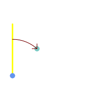
 Blue: origin Point(25,45); Green: target Point(75, 100); Yellow: Y axis or North; Red: azimuth angle.
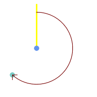
|  Blue: origin Point(75, 100); Green: target Point(25, 45); Yellow: Y axis or North; Red: azimuth angle.
|