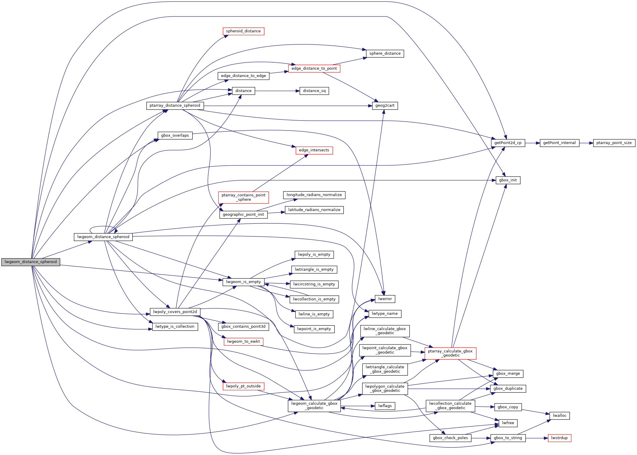
Calculate the geodetic distance from lwgeom1 to lwgeom2 on the spheroid.
A spheroid with major axis == minor axis will be treated as a sphere. Pass in a tolerance in spheroid units.
Calculate the geodetic distance from lwgeom1 to lwgeom2 on the spheroid.
Return immediately when the calculated distance drops below the tolerance (useful for dwithin calculations). Return a negative distance for incalculable cases.
2067{
2068 uint8_t type1, type2;
2071
2074
2075 assert(lwgeom1);
2076 assert(lwgeom2);
2077
2078 LWDEBUGF(4,
"entered function, tolerance %.8g", tolerance);
2079
2080
2081
2083 {
2084 return -1.0;
2085 }
2086
2087 type1 = lwgeom1->
type;
2088 type2 = lwgeom2->
type;
2089
2090
2092 gbox1 = *(lwgeom1->
bbox);
2093 else
2095
2096
2098 gbox2 = *(lwgeom2->
bbox);
2099 else
2101
2102
2105
2106
2109 {
2111
2113 pa1 = ((
LWPOINT*)lwgeom1)->point;
2114 else
2115 pa1 = ((
LWLINE*)lwgeom1)->points;
2116
2118 pa2 = ((
LWPOINT*)lwgeom2)->point;
2119 else
2120 pa2 = ((
LWLINE*)lwgeom2)->points;
2121
2123 }
2124
2125
2128 {
2133 uint32_t i;
2134
2136 {
2138 lwpoly = (
LWPOLY*)lwgeom2;
2139 }
2140 else
2141 {
2143 lwpoly = (
LWPOLY*)lwgeom1;
2144 }
2146
2147
2149 {
2150 return 0.0;
2151 }
2152
2153
2154 for ( i = 0; i < lwpoly->
nrings; i++ )
2155 {
2161 }
2163 }
2164
2165
2168 {
2173 uint32_t i;
2174
2176 {
2177 lwline = (
LWLINE*)lwgeom1;
2178 lwpoly = (
LWPOLY*)lwgeom2;
2179 }
2180 else
2181 {
2182 lwline = (
LWLINE*)lwgeom2;
2183 lwpoly = (
LWPOLY*)lwgeom1;
2184 }
2186
2187 LWDEBUG(4,
"checking if a point of line is in polygon");
2188
2189
2191 return 0.0;
2192
2193 LWDEBUG(4,
"checking ring distances");
2194
2195
2196 for ( i = 0; i < lwpoly->
nrings; i++ )
2197 {
2199 LWDEBUGF(4,
"ring[%d] ring_distance = %.8g", i, ring_distance);
2204 }
2207
2208 }
2209
2210
2211
2213 {
2218 uint32_t i, j;
2219
2220
2223
2224
2227
2228
2229 for (i = 0; i < lwpoly1->
nrings; i++)
2230 {
2231 for (j = 0; j < lwpoly2->
nrings; j++)
2232 {
2233 double ring_distance =
2237 spheroid,
2238 tolerance,
2239 check_intersection);
2243 }
2244 }
2246 }
2247
2248
2250 {
2251 uint32_t i;
2254
2255 for ( i = 0; i < col->
ngeoms; i++ )
2256 {
2258 col->
geoms[i], lwgeom2, spheroid, tolerance);
2263 }
2265 }
2266
2267
2269 {
2270 uint32_t i;
2273
2274 for ( i = 0; i < col->
ngeoms; i++ )
2275 {
2281 }
2283 }
2284
2285
2287 return -1.0;
2288
2289}
int gbox_overlaps(const GBOX *g1, const GBOX *g2)
Return LW_TRUE if the GBOX overlaps, LW_FALSE otherwise.
void gbox_init(GBOX *gbox)
Zero out all the entries in the GBOX.
const char * lwtype_name(uint8_t type)
Return the type name string associated with a type number (e.g.
int lwtype_is_collection(uint8_t type)
Determine whether a type number is a collection or not.
#define POINTTYPE
LWTYPE numbers, used internally by PostGIS.
#define LW_TRUE
Return types for functions with status returns.
#define FLAGS_GET_GEODETIC(flags)
int lwpoly_covers_point2d(const LWPOLY *poly, const POINT2D *pt_to_test)
Given a polygon (lon/lat decimal degrees) and point (lon/lat decimal degrees) and a guaranteed outsid...
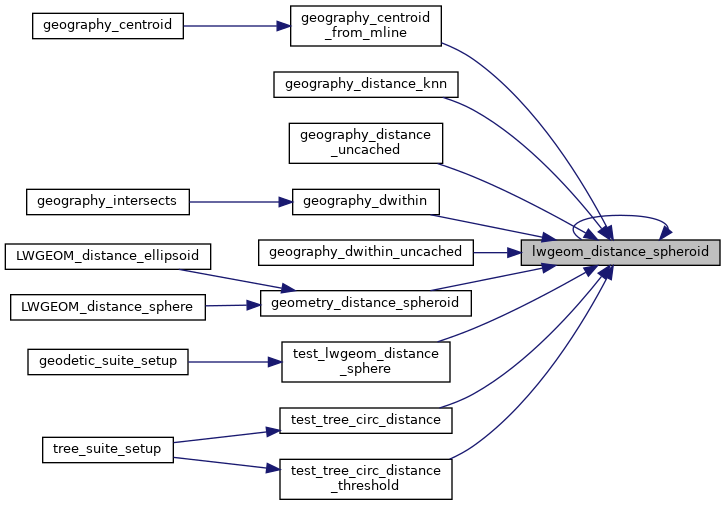
double lwgeom_distance_spheroid(const LWGEOM *lwgeom1, const LWGEOM *lwgeom2, const SPHEROID *spheroid, double tolerance)
Calculate the distance between two LWGEOMs, using the coordinates are longitude and latitude.
int lwgeom_calculate_gbox_geodetic(const LWGEOM *geom, GBOX *gbox)
Calculate the geodetic bounding box for an LWGEOM.
static double ptarray_distance_spheroid(const POINTARRAY *pa1, const POINTARRAY *pa2, const SPHEROID *s, double tolerance, int check_intersection)
#define LWDEBUG(level, msg)
#define LWDEBUGF(level, msg,...)
void void lwerror(const char *fmt,...) __attribute__((format(printf
Write a notice out to the error handler.
static int lwgeom_is_empty(const LWGEOM *geom)
Return true or false depending on whether a geometry is an "empty" geometry (no vertices members)
static const POINT2D * getPoint2d_cp(const POINTARRAY *pa, uint32_t n)
Returns a POINT2D pointer into the POINTARRAY serialized_ptlist, suitable for reading from.
static double distance(double x1, double y1, double x2, double y2)