Loading...
Searching...
No Matches
◆ ptarray_segmentize_sphere_edge_recursive()
|
static |
Definition at line 1587 of file lwgeodetic.c.
1592{
1593 GEOGRAPHIC_POINT g;
1594 /* Reached the terminal leaf in recursion. Add */
1595 /* the left-most point to the pointarray here */
1596 /* We recurse down the left side first, so outputs should */
1597 /* end up added to the array in order this way */
1598 if (d <= max_seg_length)
1599 {
1600 POINT4D p;
1601 cart2geog(p1, &g);
1607 }
1608 /* Find the mid-point and recurse on the left and then the right */
1609 else
1610 {
1611 /* Calculate mid-point */
1612 POINT3D mid;
1616 normalize(&mid);
1617
1618 /* Calculate z/m mid-values */
1619 POINT4D midv;
1620 cart2geog(&mid, &g);
1625 /* Recurse on the left first */
1626 ptarray_segmentize_sphere_edge_recursive(p1, &mid, v1, &midv, d/2.0, max_seg_length, pa);
1627 ptarray_segmentize_sphere_edge_recursive(&mid, p2, &midv, v2, d/2.0, max_seg_length, pa);
1629 }
1630}
int ptarray_append_point(POINTARRAY *pa, const POINT4D *pt, int allow_duplicates)
Append a point to the end of an existing POINTARRAY If allow_duplicate is LW_FALSE,...
Definition ptarray.c:147
void cart2geog(const POINT3D *p, GEOGRAPHIC_POINT *g)
Convert cartesian coordinates on unit sphere to spherical coordinates.
Definition lwgeodetic.c:414
static int ptarray_segmentize_sphere_edge_recursive(const POINT3D *p1, const POINT3D *p2, const POINT4D *v1, const POINT4D *v2, double d, double max_seg_length, POINTARRAY *pa)
Definition lwgeodetic.c:1587
Definition liblwgeom.h:401
Definition liblwgeom.h:413
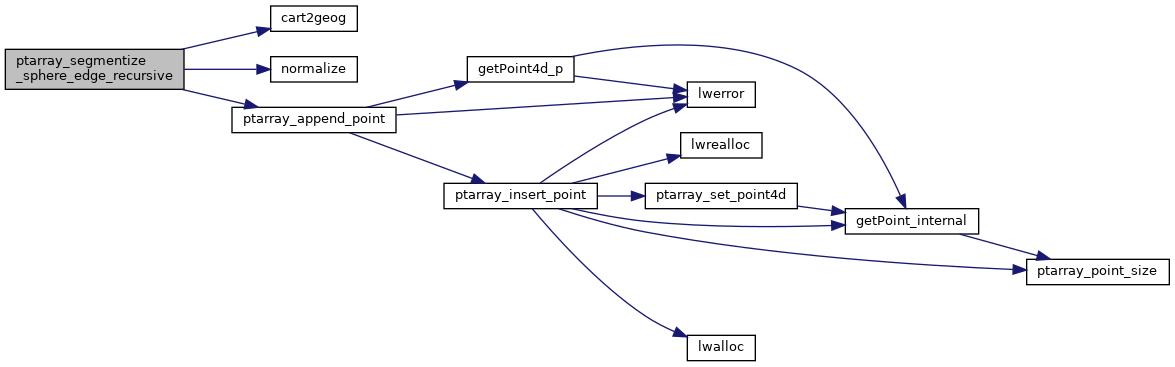
References cart2geog(), GEOGRAPHIC_POINT::lat, GEOGRAPHIC_POINT::lon, LW_FALSE, LW_SUCCESS, POINT4D::m, normalize(), ptarray_append_point(), ptarray_segmentize_sphere_edge_recursive(), rad2deg, POINT3D::x, POINT4D::x, POINT3D::y, POINT4D::y, POINT3D::z, and POINT4D::z.
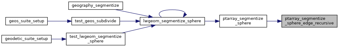
Referenced by ptarray_segmentize_sphere(), and ptarray_segmentize_sphere_edge_recursive().
Here is the call graph for this function:
Here is the caller graph for this function: