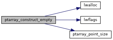
◆ ptarray_construct_empty()
| POINTARRAY* ptarray_construct_empty | ( | char | hasz, |
| char | hasm, | ||
| uint32_t | maxpoints | ||
| ) |
Create a new POINTARRAY with no points.
Allocate enough storage to hold maxpoints vertices before having to reallocate the storage area.
Definition at line 59 of file ptarray.c.
References POINTARRAY::flags, lwalloc(), lwflags(), POINTARRAY::maxpoints, POINTARRAY::npoints, ptarray_point_size(), and POINTARRAY::serialized_pointlist.
Referenced by BOX2D_to_LWGEOM(), BOX3D_to_LWGEOM(), encode_mpoint(), gbox_to_gml2(), gbox_to_gml3(), GenerateLineStringGeometry(), GeneratePointGeometry(), GeneratePolygonGeometry(), geography_centroid_from_mpoly(), lwarc_linearize(), lwcircstring_construct_empty(), lwcircstring_get_lwpoint(), lwcircstring_linearize(), lwcompound_linearize(), LWGEOM_envelope(), lwgeom_from_encoded_polyline(), lwline_clip_to_ordinate_range(), lwline_construct_empty(), lwline_from_lwgeom_array(), lwline_from_ptarray(), lwline_get_lwpoint(), lwline_interpolate_points(), lwline_split_by_point_to(), lwpoint_make(), lwpoint_make2d(), lwpoint_make3dm(), lwpoint_make3dz(), lwpoint_make4d(), lwpoly_construct_circle(), lwpoly_construct_rectangle(), lwtriangle_clip_to_ordinate_range(), lwtriangle_construct_empty(), parse_geojson_linestring(), parse_geojson_multilinestring(), parse_geojson_multipoint(), parse_geojson_point(), parse_geojson_poly_rings(), parse_gml_coord(), parse_gml_coordinates(), parse_gml_pos(), parse_gml_poslist(), parse_kml_coordinates(), path_to_geometry(), polygon_to_geometry(), ptarray_chaikin(), ptarray_clamp_to_ordinate_range(), ptarray_construct(), ptarray_force_dims(), ptarray_from_twkb_state(), ptarray_locate_along(), ptarray_locate_between_m(), ptarray_segmentize2d(), ptarray_segmentize_sphere(), ptarray_set_effective_area(), ptarray_substring(), rt_raster_get_convex_hull(), rt_raster_get_envelope_geom(), RTreeCreateLeafNode(), ST_BoundingDiagonal(), test_trim_bits(), and wkt_parser_ptarray_new().
