제목
ST_Clip — Returns the raster clipped by the input geometry. If band number is not specified, all bands are processed. If crop is not specified or TRUE, the output raster is cropped. If touched is set to TRUE, then touched pixels are included, otherwise only if the center of the pixel is in the geometry it is included.
요약
raster ST_Clip(raster rast, integer[] nband, geometry geom, double precision[] nodataval=NULL, boolean crop=TRUE, boolean touched=FALSE);
raster ST_Clip(raster rast, integer nband, geometry geom, double precision nodataval, boolean crop=TRUE, boolean touched=FALSE);
raster ST_Clip(raster rast, integer nband, geometry geom, boolean crop, boolean touched=FALSE);
raster ST_Clip(raster rast, geometry geom, double precision[] nodataval=NULL, boolean crop=TRUE, boolean touched=FALSE);
raster ST_Clip(raster rast, geometry geom, double precision nodataval, boolean crop=TRUE, boolean touched=FALSE);
raster ST_Clip(raster rast, geometry geom, boolean crop, boolean touched=FALSE);
Description
입력 도형 geom 으로 잘라낸 래스터를 반환합니다. 밴드 인덱스를 지정하지 않을 경우, 모든 밴드를 처리합니다.
ST_Clip이 출력한 래스터는 각 밴드에 대해 잘라낸 면에 할당된 NODATA 값을 가지고 있어야 합니다. NODATA 값을 설정하지 않고 입력 래스터에 정의된 NODATA 값이 없을 경우, 출력 래스터의 NODATA 값을 ST_MinPossibleValue(ST_BandPixelType(rast, band))로 설정합니다. 배열 내부의 NODATA 값의 개수가 밴드 개수보다 작을 경우, 배열 안의 마지막 NODATA 값을 남은 밴드의 NODATA 값으로 씁니다. NODATA 값의 개수가 밴드 개수보다 클 경우, 남는 NODATA 값을 무시합니다. NODATA 값의 배열을 입력받는 모든 변종 함수는 각 밴드에 할당될 단일 값도 입력받습니다.
If crop is not specified, true is assumed meaning the output raster is cropped to the intersection of the geomand rast extents. If crop is set to false, the new raster gets the same extent as rast. If touched is set to true, then all pixels in the rast that intersect the geometry are selected.
![[참고]](../images/note.png)
|
|
|
The default behavior is touched=false, which will only select pixels where the center of the pixel is covered by the geometry. |
Enhanced: 3.5.0 - touched argument added.
2.0.0 버전부터 사용할 수 있습니다.
개선 사항: 2.1.0 버전에서 C 언어로 다시 쓰였습니다.
Examples here use Massachusetts aerial data available on MassGIS site MassGIS Aerial Orthos.
예시
Comparing selecting all touched vs. not all touched.
WITH source AS (
    SELECT rast, geom
    FROM ST_AsRaster(ST_Letters('R'), scalex =
> 1.0, scaley =
> -1.0) AS r(rast)
    INNER JOIN ST_GeomFromText('LINESTRING(0 1,5 6,10 10)') AS g(geom)
        ON ST_Intersects(r.rast, g.geom)
), clipped AS (
    SELECT rast,
        ST_Clip(rast, geom, touched =
> true) AS rast_touched,
        ST_Clip(rast, geom, touched =
> false) AS rast_not_touched
    FROM source
), variants AS (
    SELECT 'original' AS title, ST_Count(rast) AS pixel_count, rast AS rendered
    FROM clipped
    UNION ALL
    SELECT 'all touched', ST_Count(rast_touched), rast_touched
    FROM clipped
    UNION ALL
    SELECT 'default clip', ST_Count(rast_not_touched), rast_not_touched
    FROM clipped
)
SELECT title, pixel_count, ST_AsPNG(rendered) AS image
FROM variants
ORDER BY CASE title
    WHEN 'original' THEN 1
    WHEN 'all touched' THEN 2
    ELSE 3
END;
title        | pixel_count | image
--------------+-------------+----------------------------
 original     |        2605 | PNG image, 48 x 74 pixels
 all touched  |          16 | PNG image, 11 x 11 pixels
 default clip |          10 | PNG image, 11 x 11 pixels
(3 rows)
The following self-contained example uses three simple shapes as RGB bands. It compares cropping band 1, clipping band 1 without cropping and then restoring bands 2 and 3, and clipping every band without cropping.
WITH canvas AS (
    SELECT ST_AddBand(
        ST_AddBand(
            ST_AddBand(
                ST_MakeEmptyRaster(128, 128, 0, 128, 1, -1, 0, 0, 0),
                '8BUI'::text, 0::double precision, 0::double precision
            ),
            '8BUI'::text, 0::double precision, 0::double precision
        ),
        '8BUI'::text, 0::double precision, 0::double precision
    ) AS rast
), source AS (
    SELECT ST_SetValue(
        ST_SetValue(
            ST_SetValue(rast, 1, ST_Buffer('POINT(32 96)'::geometry, 22), 220),
            2, ST_Buffer('LINESTRING(18 20,110 110)'::geometry, 6,
                         'endcap=flat join=bevel'), 210
        ),
        3, ST_Buffer('LINESTRING(10 48,118 48)'::geometry, 7,
                     'endcap=flat'), 180
    ) AS rast,
    ST_Buffer('POINT(64 64)'::geometry, 34) AS clipper
    FROM canvas
), variants AS (
    SELECT 'original RGB' AS title, rast AS rendered FROM source
    UNION ALL
    SELECT 'band 1 cropped', ST_Clip(rast, 1, clipper, true) FROM source
    UNION ALL
    SELECT
        'band 1 only',
        ST_AddBand(
            ST_Clip(rast, 1, clipper, false),
            ARRAY[ST_Band(rast, 2), ST_Band(rast, 3)]
        )
    FROM source
    UNION ALL
    SELECT 'all bands clipped', ST_Clip(rast, clipper, false) FROM source
)
SELECT title, ST_AsPNG(rendered) AS image
FROM variants
ORDER BY CASE title
    WHEN 'original RGB' THEN 1
    WHEN 'band 1 cropped' THEN 2
    WHEN 'band 1 only' THEN 3
    ELSE 4
END;
title             | image
-------------------+-----------------------------
 original RGB      | PNG image, 128 x 128 pixels
 band 1 cropped    | PNG image, 68 x 68 pixels
 band 1 only       | PNG image, 128 x 128 pixels
 all bands clipped | PNG image, 128 x 128 pixels
(4 rows)
Crop, single-band clipping, and all-band clipping.
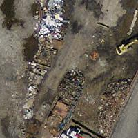
Source tile |
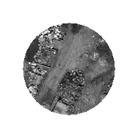
Cropped |
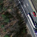
One-band source |
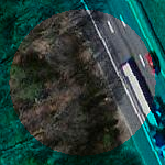
One-band clip |
|
All-band source |
All-band clip |