Name
ST_ClusterKMeans — 入力ジオメトリごとにk平均法アルゴリズムを使ってクラスタ番号を返すウィンドウ関数です。
Synopsis
integer ST_ClusterKMeans(geometry winset geom, integer number_of_clusters, float max_radius);
説明
入力ジオメトリごとのK平均法のクラスタ番号を返します。クラスタリングに使われる距離は、2次元ジオメトリでは重心間の距離、3次元ジオメトリではバウンディングボックスの中心点間の距離です。POINT入力では、M値は入力の重みとして扱われ、0より大きくなければなりません。
max_radiusが設定されている場合には、ST_ClusterKMeansは、出力クラスタがmax_radiusより半径が大きいクラスタを作らなくなるので、kより多いクラスタを生成します。到達可能性分析に使います。
Enhanced: 3.2.0 max_radiusパラメータに対応しました
Enhanced: 3.1.0 3次元ジオメトリと重みに対応するようになりました
Availability: 2.3.0
例
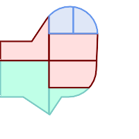
例としてダミーの区画の集合を生成します:
CREATE TABLE parcels AS
SELECT lpad((row_number() over())::text,3,'0') As parcel_id, geom,
('{residential, commercial}'::text[])[1 + mod(row_number()OVER(),2)] As type
FROM
    ST_Subdivide(ST_Buffer('SRID=3857;LINESTRING(40 100, 98 100, 100 150, 60 90)'::geometry,
    40, 'endcap=square'),12) As geom;

クラスタ番号 (cid)による色付けを施した区画
SELECT ST_ClusterKMeans(geom, 3) OVER() AS cid, parcel_id, geom
    FROM parcels;
cid | parcel_id |   geom
-----+-----------+---------------
   0 | 001       | 0103000000...
   0 | 002       | 0103000000...
   1 | 003       | 0103000000...
   0 | 004       | 0103000000...
   1 | 005       | 0103000000...
   2 | 006       | 0103000000...
   2 | 007       | 0103000000...
タイプ別による区画の分割:
SELECT ST_ClusterKMeans(geom, 3) over (PARTITION BY type) AS cid, parcel_id, type
    FROM parcels;
cid | parcel_id |    type
-----+-----------+-------------
   1 | 005       | commercial
   1 | 003       | commercial
   2 | 007       | commercial
   0 | 001       | commercial
   1 | 004       | residential
   0 | 002       | residential
   2 | 006       | residential
例: 3次元クラスタリングと重み付けを使った、事前集計した地球規模の人口データセットのクラスタリング。Kontur Population Dataに基づいて、中心から3000km以下となる、少なくとも 20 の地域が識別されます:
create table kontur_population_3000km_clusters as
select
    geom,
    ST_ClusterKMeans(
        ST_Force4D(
            ST_Transform(ST_Force3D(geom), 4978), -- cluster in 3D XYZ CRS
            mvalue => population -- set clustering to be weighed by population
        ),
        20,                      -- aim to generate at least 20 clusters
        max_radius => 3000000    -- but generate more to make each under 3000 km radius
    ) over () as cid
from
    kontur_population;

世界人口を上記仕様でクラスタリングして、46のクラスタを得ました。人口集中地域 (ニューヨーク、モスクワ)にクラスタの中心が来ます。グリーンランドは一つのクラスタです。日付変更線をまたぐクラスタがあります。クラスタのエッジは地球の曲線に従います。