Loading...
Searching...
No Matches
◆ rt_raster_same_alignment()
| rt_errorstate rt_raster_same_alignment | ( | rt_raster | rast1, |
| rt_raster | rast2, | ||
| int * | aligned, | ||
| char ** | reason | ||
| ) |
Definition at line 45 of file rt_spatial_relationship.c.
49 {
50 double xr;
51 double yr;
52 double xw;
53 double yw;
54 int err = 0;
55
56 assert(NULL != rast1);
57 assert(NULL != rast2);
58 assert(NULL != aligned);
59
60 err = 0;
61 /* same srid */
63 if (reason != NULL) *reason = "The rasters have different SRIDs";
64 err = 1;
65 }
66 /* scales must match */
68 if (reason != NULL) *reason = "The rasters have different scales on the X axis";
69 err = 1;
70 }
72 if (reason != NULL) *reason = "The rasters have different scales on the Y axis";
73 err = 1;
74 }
75 /* skews must match */
77 if (reason != NULL) *reason = "The rasters have different skews on the X axis";
78 err = 1;
79 }
81 if (reason != NULL) *reason = "The rasters have different skews on the Y axis";
82 err = 1;
83 }
84
85 if (err) {
86 *aligned = 0;
88 }
89
90 /* raster coordinates in context of second raster of first raster's upper-left corner */
92 rast2,
94 &xr, &yr,
95 NULL
96 ) != ES_NONE) {
97 rterror("rt_raster_same_alignment: Could not get raster coordinates of second raster from first raster's spatial coordinates");
98 *aligned = 0;
100 }
101
102 /* spatial coordinates of raster coordinates from above */
104 rast2,
105 xr, yr,
106 &xw, &yw,
107 NULL
108 ) != ES_NONE) {
109 rterror("rt_raster_same_alignment: Could not get spatial coordinates of second raster from raster coordinates");
110 *aligned = 0;
112 }
113
117
118 /* spatial coordinates are identical to that of first raster's upper-left corner */
120 if (reason != NULL) *reason = "The rasters are aligned";
121 *aligned = 1;
123 }
124
125 /* no alignment */
126 if (reason != NULL) *reason = "The rasters (pixel corner coordinates) are not aligned";
127
128 *aligned = 0;
130}
void rterror(const char *fmt,...) __attribute__((format(printf
Wrappers used for reporting errors and info.
rt_errorstate rt_raster_cell_to_geopoint(rt_raster raster, double xr, double yr, double *xw, double *yw, double *gt)
Convert an xr, yr raster point to an xw, yw point on map.
Definition rt_raster.c:637
rt_errorstate rt_raster_geopoint_to_cell(rt_raster raster, double xw, double yw, double *xr, double *yr, double *igt)
Convert an xw, yw map point to a xr, yr raster point.
Definition rt_raster.c:686
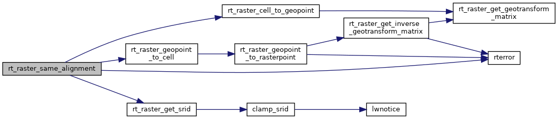
References ES_ERROR, ES_NONE, FLT_EQ, FLT_NEQ, rt_raster_t::ipX, rt_raster_t::ipY, RASTER_DEBUGF, rt_raster_cell_to_geopoint(), rt_raster_geopoint_to_cell(), rt_raster_get_srid(), rterror(), rt_raster_t::scaleX, rt_raster_t::scaleY, rt_raster_t::skewX, and rt_raster_t::skewY.
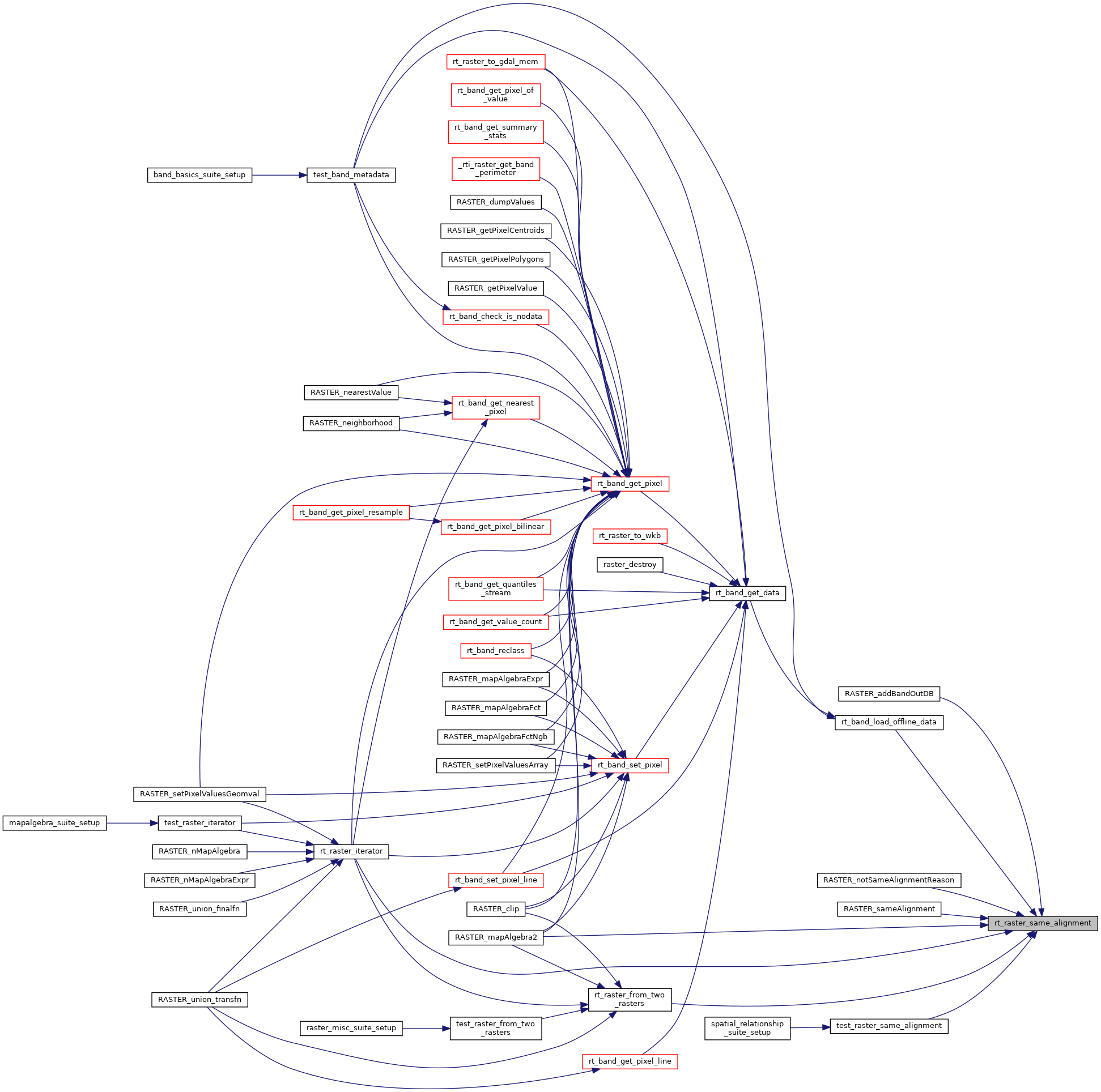
Referenced by diff_rastinfo(), RASTER_addBandOutDB(), RASTER_mapAlgebra2(), RASTER_notSameAlignmentReason(), RASTER_sameAlignment(), rt_band_load_offline_data(), rt_raster_from_two_rasters(), rt_raster_iterator(), and test_raster_same_alignment().
Here is the call graph for this function:
Here is the caller graph for this function: