PostGIS  3.7.0dev-r@@SVN_REVISION@@

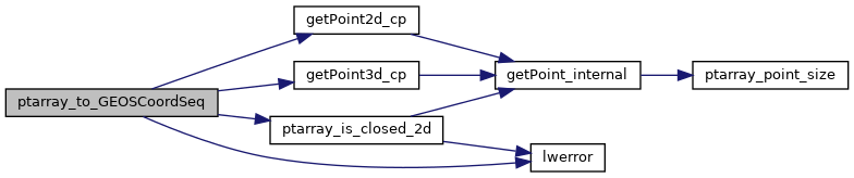
◆ ptarray_to_GEOSCoordSeq()

GEOSCoordSeq ptarray_to_GEOSCoordSeq ( const POINTARRAY pa,
uint8_t  fix_ring 
)

Definition at line 275 of file liblwgeom/lwgeom_geos.c.

276 {
277  uint32_t dims = 2;
278  uint32_t i;
279  int append_points = 0;
280  const POINT3D *p3d = NULL;
281  const POINT2D* p2d = NULL;
282  GEOSCoordSeq sq;
283 
284  if (FLAGS_GET_Z(pa->flags)) dims = 3;
285 
286  if (fix_ring)
287  {
288  if (pa->npoints < 1)
289  {
290  lwerror("ptarray_to_GEOSCoordSeq called with fix_ring and 0 vertices in ring, cannot fix");
291  return NULL;
292  }
293  else
294  {
295  if (pa->npoints < 4) append_points = 4 - pa->npoints;
296  if (!ptarray_is_closed_2d(pa) && append_points == 0) append_points = 1;
297  }
298  }
299 
300 #if POSTGIS_GEOS_VERSION >= 31000
301  if (append_points == 0) {
302  sq = GEOSCoordSeq_copyFromBuffer((const double*) pa->serialized_pointlist, pa->npoints, FLAGS_GET_Z(pa->flags), FLAGS_GET_M(pa->flags));
303  if (!sq)
304  {
305  GEOS_FAIL();
306  }
307  return sq;
308  }
309 #endif
310  if (!(sq = GEOSCoordSeq_create(pa->npoints + append_points, dims)))
311  {
312  GEOS_FAIL();
313  }
314 
315  for (i = 0; i < pa->npoints; i++)
316  {
317  if (dims == 3)
318  {
319  p3d = getPoint3d_cp(pa, i);
320  p2d = (const POINT2D*)p3d;
321  LWDEBUGF(4, "Point: %g,%g,%g", p3d->x, p3d->y, p3d->z);
322  }
323  else
324  {
325  p2d = getPoint2d_cp(pa, i);
326  LWDEBUGF(4, "Point: %g,%g", p2d->x, p2d->y);
327  }
328 
329  if (dims == 3)
330  GEOSCoordSeq_setXYZ(sq, i, p2d->x, p2d->y, p3d->z);
331  else
332  GEOSCoordSeq_setXY(sq, i, p2d->x, p2d->y);
333 
334  }
335 
336  if (append_points)
337  {
338  if (dims == 3)
339  {
340  p3d = getPoint3d_cp(pa, 0);
341  p2d = (const POINT2D*)p3d;
342  }
343  else
344  p2d = getPoint2d_cp(pa, 0);
345  for (i = pa->npoints; i < pa->npoints + append_points; i++)
346  {
347 
348  GEOSCoordSeq_setXY(sq, i, p2d->x, p2d->y);
349 
350  if (dims == 3) GEOSCoordSeq_setZ(sq, i, p3d->z);
351  }
352  }
353 
354  return sq;
355 
356 }
#define GEOS_FAIL()
#define FLAGS_GET_Z(flags)
Definition: liblwgeom.h:165
#define FLAGS_GET_M(flags)
Definition: liblwgeom.h:166
int ptarray_is_closed_2d(const POINTARRAY *pa)
Definition: ptarray.c:710
#define LWDEBUGF(level, msg,...)
Definition: lwgeom_log.h:106
void void lwerror(const char *fmt,...) __attribute__((format(printf
Write a notice out to the error handler.
static const POINT2D * getPoint2d_cp(const POINTARRAY *pa, uint32_t n)
Returns a POINT2D pointer into the POINTARRAY serialized_ptlist, suitable for reading from.
Definition: lwinline.h:97
static const POINT3D * getPoint3d_cp(const POINTARRAY *pa, uint32_t n)
Returns a POINT3D pointer into the POINTARRAY serialized_ptlist, suitable for reading from.
Definition: lwinline.h:109
double y
Definition: liblwgeom.h:390
double x
Definition: liblwgeom.h:390
double z
Definition: liblwgeom.h:402
double x
Definition: liblwgeom.h:402
double y
Definition: liblwgeom.h:402
lwflags_t flags
Definition: liblwgeom.h:431
uint32_t npoints
Definition: liblwgeom.h:427
uint8_t * serialized_pointlist
Definition: liblwgeom.h:434

References POINTARRAY::flags, FLAGS_GET_M, FLAGS_GET_Z, GEOS_FAIL, getPoint2d_cp(), getPoint3d_cp(), LWDEBUGF, lwerror(), POINTARRAY::npoints, ptarray_is_closed_2d(), POINTARRAY::serialized_pointlist, POINT2D::x, POINT3D::x, POINT2D::y, POINT3D::y, and POINT3D::z.

Referenced by LWGEOM2GEOS(), and ptarray_to_GEOSLinearRing().

Here is the call graph for this function:
Here is the caller graph for this function: