PostGIS
3.4.0dev-r@@SVN_REVISION@@
Main Page
Related Pages
Namespaces
Namespace List
Namespace Members
All
a
b
c
d
f
g
h
i
l
m
n
o
p
q
r
s
t
u
v
w
x
y
Functions
c
d
f
g
i
l
m
p
q
w
Variables
a
b
c
d
f
g
h
i
l
n
o
p
r
s
t
u
v
x
y
Data Structures
Data Structures
Data Structure Index
Class Hierarchy
Data Fields
All
_
a
b
c
d
e
f
g
h
i
j
k
l
m
n
o
p
q
r
s
t
u
v
w
x
y
z
Functions
Variables
a
b
c
d
e
f
g
h
i
j
k
l
m
n
o
p
q
r
s
t
u
v
w
x
y
z
Enumerator
Properties
Files
File List
Globals
All
_
a
b
c
d
e
f
g
h
i
j
k
l
m
n
o
p
q
r
s
t
u
v
w
x
y
z
Functions
_
a
b
c
d
e
f
g
h
i
j
k
l
m
n
o
p
q
r
s
t
u
v
w
x
y
z
Variables
_
a
b
c
d
e
g
h
i
l
m
n
o
p
r
s
t
v
w
y
Typedefs
_
b
c
d
e
f
g
h
i
l
m
n
p
r
s
t
u
y
Enumerations
Enumerator
a
c
d
e
f
g
i
j
l
m
p
r
s
t
u
Macros
_
a
b
c
d
e
f
g
h
i
j
k
l
m
n
o
p
r
s
t
u
v
w
x
y
Examples
►
PostGIS
•
All
Data Structures
Namespaces
Files
Functions
Variables
Typedefs
Enumerations
Enumerator
Properties
Macros
Pages
◆
rt_util_gdal_supported_sr()
int rt_util_gdal_supported_sr
(
const char *
srs
)
Definition at line
249
of file
rt_util.c
.
249
{
250
OGRSpatialReferenceH hsrs;
251
OGRErr rtn = OGRERR_NONE;
252
253
assert(srs != NULL);
254
255
hsrs = OSRNewSpatialReference(NULL);
256
rtn = OSRSetFromUserInput(hsrs, srs);
257
OSRDestroySpatialReference(hsrs);
258
259
if
(rtn == OGRERR_NONE)
260
return
1;
261
else
262
return
0;
263
}
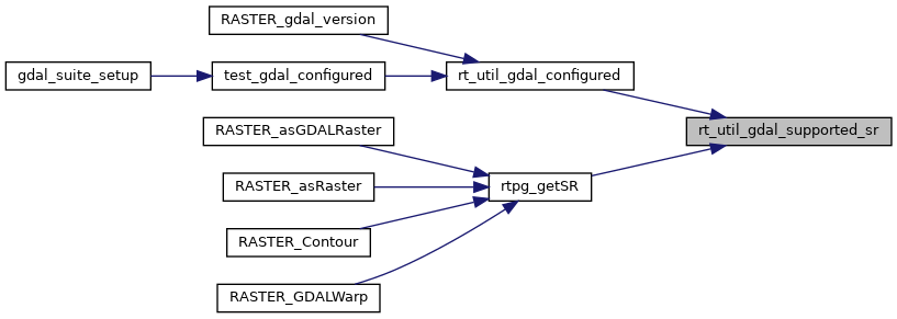
Referenced by
rt_util_gdal_configured()
, and
rtpg_getSR()
.
Here is the caller graph for this function:
raster
rt_core
rt_util.c
Generated by
1.9.1