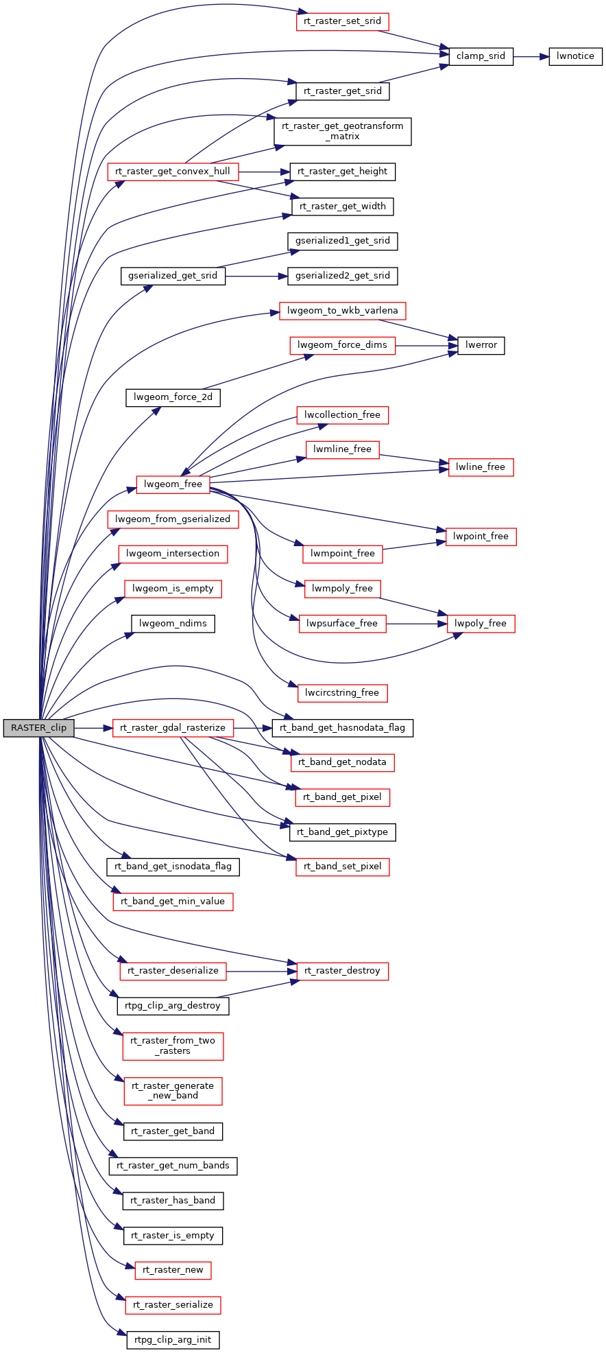
3000 double offset[4] = {0.};
3010 int mask_height = 0;
3020 if (PG_ARGISNULL(0) || PG_ARGISNULL(2))
3026 elog(ERROR,
"RASTER_clip: Could not initialize argument structure");
3031 pgraster = (
rt_pgraster *) PG_DETOAST_DATUM(PG_GETARG_DATUM(0));
3035 if (arg->
raster == NULL) {
3037 PG_FREE_IF_COPY(pgraster, 0);
3038 elog(ERROR,
"RASTER_clip: Could not deserialize raster");
3044 elog(NOTICE,
"Input raster is empty or has no bands. Returning empty raster");
3047 PG_FREE_IF_COPY(pgraster, 0);
3051 elog(ERROR,
"RASTER_clip: Could not create empty raster");
3060 SET_VARSIZE(pgrtn, pgrtn->
size);
3061 PG_RETURN_POINTER(pgrtn);
3069 gser = PG_GETARG_GSERIALIZED_P(2);
3081 elog(NOTICE,
"Geometry provided does not have the same SRID as the raster. Returning NULL");
3084 PG_FREE_IF_COPY(pgraster, 0);
3086 PG_FREE_IF_COPY(gser, 2);
3092 if (!PG_ARGISNULL(4) && !PG_GETARG_BOOL(4))
3099 PG_FREE_IF_COPY(pgraster, 0);
3101 PG_FREE_IF_COPY(gser, 2);
3103 elog(ERROR,
"RASTER_clip: Could not get convex hull of raster");
3110 PG_FREE_IF_COPY(gser, 2);
3115 elog(NOTICE,
"The input raster and input geometry do not intersect. Returning empty raster");
3118 PG_FREE_IF_COPY(pgraster, 0);
3123 elog(ERROR,
"RASTER_clip: Could not create empty raster");
3132 SET_VARSIZE(pgrtn, pgrtn->
size);
3133 PG_RETURN_POINTER(pgrtn);
3137 if (!PG_ARGISNULL(1)) {
3138 array = PG_GETARG_ARRAYTYPE_P(1);
3139 etype = ARR_ELEMTYPE(array);
3140 get_typlenbyvalalign(etype, &typlen, &typbyval, &typalign);
3148 PG_FREE_IF_COPY(pgraster, 0);
3150 elog(ERROR,
"RASTER_clip: Invalid data type for band indexes");
3157 typlen, typbyval, typalign,
3162 if (arg->
band == NULL) {
3164 PG_FREE_IF_COPY(pgraster, 0);
3166 elog(ERROR,
"RASTER_clip: Could not allocate memory for band arguments");
3170 for (i = 0, j = 0; i < arg->
numbands; i++) {
3171 if (nulls[i])
continue;
3175 arg->
band[j].
nband = DatumGetInt16(e[i]) - 1;
3178 arg->
band[j].
nband = DatumGetInt32(e[i]) - 1;
3185 if (j < arg->numbands) {
3187 if (arg->
band == NULL) {
3189 PG_FREE_IF_COPY(pgraster, 0);
3191 elog(ERROR,
"RASTER_clip: Could not reallocate memory for band arguments");
3199 for (i = 0; i < arg->
numbands; i++) {
3201 elog(NOTICE,
"Band at index %d not found in raster", arg->
band[i].
nband + 1);
3203 PG_FREE_IF_COPY(pgraster, 0);
3218 if (arg->
band == NULL) {
3221 PG_FREE_IF_COPY(pgraster, 0);
3224 elog(ERROR,
"RASTER_clip: Could not allocate memory for band arguments");
3228 for (i = 0; i < arg->
numbands; i++) {
3237 if (!PG_ARGISNULL(3)) {
3238 array = PG_GETARG_ARRAYTYPE_P(3);
3239 etype = ARR_ELEMTYPE(array);
3240 get_typlenbyvalalign(etype, &typlen, &typbyval, &typalign);
3248 PG_FREE_IF_COPY(pgraster, 0);
3250 elog(ERROR,
"RASTER_clip: Invalid data type for NODATA values");
3257 typlen, typbyval, typalign,
3262 for (i = 0, j = 0; i < arg->
numbands; i++, j++) {
3310 if (arg->
mask == NULL) {
3312 PG_FREE_IF_COPY(pgraster, 0);
3313 elog(ERROR,
"RASTER_clip: Could not rasterize intersection geometry");
3325 PG_FREE_IF_COPY(pgraster, 0);
3326 elog(ERROR,
"RASTER_clip: Could not compute extent of rasters");
3335 for (i = 0; i < arg->
numbands; i++) {
3356 PG_FREE_IF_COPY(pgraster, 0);
3357 elog(ERROR,
"RASTER_clip: Could not add new band in output raster");
3371 for (
y = 0;
y < height;
y++) {
3372 for (
x = 0;
x < width;
x++) {
3373 mask_x =
x - (int)offset[2];
3374 mask_y =
y - (int)offset[3];
3378 mask_x < mask_width &&
3380 mask_y < mask_height
3387 PG_FREE_IF_COPY(pgraster, 0);
3388 elog(ERROR,
"RASTER_clip: Could not get pixel value");
3396 input_x =
x - (int)offset[0];
3397 input_y =
y - (int)offset[1];
3401 PG_FREE_IF_COPY(pgraster, 0);
3402 elog(ERROR,
"RASTER_clip: Could not get pixel value");
3412 PG_FREE_IF_COPY(pgraster, 0);
3413 elog(ERROR,
"RASTER_clip: Could not set pixel value");
3421 PG_FREE_IF_COPY(pgraster, 0);
3431 SET_VARSIZE(pgrtn, pgrtn->
size);
3432 PG_RETURN_POINTER(pgrtn);
int32_t gserialized_get_srid(const GSERIALIZED *g)
Extract the SRID from the serialized form (it is packed into three bytes so this is a handy function)...
LWGEOM * lwgeom_from_gserialized(const GSERIALIZED *g)
Allocate a new LWGEOM from a GSERIALIZED.
int lwgeom_ndims(const LWGEOM *geom)
Return the number of dimensions (2, 3, 4) in a geometry.
void lwgeom_free(LWGEOM *geom)
LWGEOM * lwgeom_intersection(const LWGEOM *geom1, const LWGEOM *geom2)
#define LWSIZE_GET(varsize)
Macro for reading the size from the GSERIALIZED size attribute.
#define SRID_UNKNOWN
Unknown SRID value.
lwvarlena_t * lwgeom_to_wkb_varlena(const LWGEOM *geom, uint8_t variant)
int32_t clamp_srid(int32_t srid)
Return a valid SRID from an arbitrary integer Raises a notice if what comes out is different from wha...
LWGEOM * lwgeom_force_2d(const LWGEOM *geom)
Strip out the Z/M components of an LWGEOM.
int32_t rt_raster_get_srid(rt_raster raster)
Get raster's SRID.
int rt_raster_generate_new_band(rt_raster raster, rt_pixtype pixtype, double initialvalue, uint32_t hasnodata, double nodatavalue, int index)
Generate a new inline band and add it to a raster.
int rt_band_get_hasnodata_flag(rt_band band)
Get hasnodata flag value.
rt_errorstate rt_band_get_pixel(rt_band band, int x, int y, double *value, int *nodata)
Get pixel value.
void rt_raster_destroy(rt_raster raster)
Release memory associated to a raster.
int rt_band_get_isnodata_flag(rt_band band)
Get isnodata flag value.
rt_raster rt_raster_new(uint32_t width, uint32_t height)
Construct a raster with given dimensions.
int rt_raster_has_band(rt_raster raster, int nband)
Return TRUE if the raster has a band of this number.
void * rt_raster_serialize(rt_raster raster)
Return this raster in serialized form.
double rt_band_get_min_value(rt_band band)
Returns the minimal possible value for the band according to the pixel type.
rt_errorstate rt_band_set_pixel(rt_band band, int x, int y, double val, int *converted)
Set single pixel's value.
rt_raster rt_raster_gdal_rasterize(const unsigned char *wkb, uint32_t wkb_len, const char *srs, uint32_t num_bands, rt_pixtype *pixtype, double *init, double *value, double *nodata, uint8_t *hasnodata, int *width, int *height, double *scale_x, double *scale_y, double *ul_xw, double *ul_yw, double *grid_xw, double *grid_yw, double *skew_x, double *skew_y, char **options)
Return a raster of the provided geometry.
uint16_t rt_raster_get_num_bands(rt_raster raster)
rt_errorstate rt_raster_get_convex_hull(rt_raster raster, LWGEOM **hull)
Get raster's convex hull.
uint16_t rt_raster_get_height(rt_raster raster)
void rt_raster_set_srid(rt_raster raster, int32_t srid)
Set raster's SRID.
rt_errorstate rt_band_get_nodata(rt_band band, double *nodata)
Get NODATA value.
rt_pixtype rt_band_get_pixtype(rt_band band)
Return pixeltype of this band.
uint16_t rt_raster_get_width(rt_raster raster)
rt_errorstate rt_raster_from_two_rasters(rt_raster rast1, rt_raster rast2, rt_extenttype extenttype, rt_raster *rtnraster, double *offset)
void rt_raster_get_geotransform_matrix(rt_raster raster, double *gt)
Get 6-element array of raster geotransform matrix.
rt_raster rt_raster_deserialize(void *serialized, int header_only)
Return a raster from a serialized form.
int rt_raster_is_empty(rt_raster raster)
Return TRUE if the raster is empty.
rt_band rt_raster_get_band(rt_raster raster, int bandNum)
Return Nth band, or NULL if unavailable.
static int lwgeom_is_empty(const LWGEOM *geom)
Return true or false depending on whether a geometry is an "empty" geometry (no vertices members)
static rtpg_clip_arg rtpg_clip_arg_init()
static void rtpg_clip_arg_destroy(rtpg_clip_arg arg)
#define POSTGIS_RT_DEBUG(level, msg)
