PostGIS  3.4.0dev-r@@SVN_REVISION@@

◆ ShpLoaderOpenShape()

int ShpLoaderOpenShape ( SHPLOADERSTATE state)

Definition at line 842 of file shp2pgsql-core.c.

843 {
844  SHPObject *obj = NULL;
845  int ret = SHPLOADEROK;
846  char name[MAXFIELDNAMELEN];
848  char *utf8str;
849 
850  /* If we are reading the entire shapefile, open it */
851  if (state->config->readshape == 1)
852  {
853  state->hSHPHandle = SHPOpen(state->config->shp_file, "rb");
854 
855  if (state->hSHPHandle == NULL)
856  {
857  snprintf(state->message, SHPLOADERMSGLEN, _("%s: shape (.shp) or index files (.shx) can not be opened, will just import attribute data."), state->config->shp_file);
858  state->config->readshape = 0;
859 
860  ret = SHPLOADERWARN;
861  }
862  }
863 
864  /* Open the DBF (attributes) file */
865  state->hDBFHandle = DBFOpen(state->config->shp_file, "rb");
866  if ((state->hSHPHandle == NULL && state->config->readshape == 1) || state->hDBFHandle == NULL)
867  {
868  snprintf(state->message, SHPLOADERMSGLEN, _("%s: dbf file (.dbf) can not be opened."), state->config->shp_file);
869 
870  return SHPLOADERERR;
871  }
872 
873 
874  /* Open the column map if one was specified */
875  if (state->config->column_map_filename)
876  {
877  ret = colmap_read(state->config->column_map_filename,
878  &state->column_map, state->message, SHPLOADERMSGLEN);
879  if (!ret) return SHPLOADERERR;
880  }
881 
882  /* User hasn't altered the default encoding preference... */
883  if ( strcmp(state->config->encoding, ENCODING_DEFAULT) == 0 )
884  {
885  /* But the file has a code page entry... */
886  if ( state->hDBFHandle->pszCodePage )
887  {
888  /* And we figured out what iconv encoding it maps to, so use it! */
889  char *newencoding = NULL;
890  if ( (newencoding = codepage2encoding(state->hDBFHandle->pszCodePage)) )
891  {
892  lwfree(state->config->encoding);
893  state->config->encoding = newencoding;
894  }
895  }
896  }
897 
898  /* If reading the whole shapefile (not just attributes)... */
899  if (state->config->readshape == 1)
900  {
901  SHPGetInfo(state->hSHPHandle, &state->num_entities, &state->shpfiletype, NULL, NULL);
902 
903  /* If null_policy is set to abort, check for NULLs */
904  if (state->config->null_policy == POLICY_NULL_ABORT)
905  {
906  /* If we abort on null items, scan the entire file for NULLs */
907  for (int j = 0; j < state->num_entities; j++)
908  {
909  obj = SHPReadObject(state->hSHPHandle, j);
910 
911  if (!obj)
912  {
913  snprintf(state->message, SHPLOADERMSGLEN, _("Error reading shape object %d"), j);
914  return SHPLOADERERR;
915  }
916 
917  if (obj->nVertices == 0)
918  {
919  snprintf(state->message, SHPLOADERMSGLEN, _("Empty geometries found, aborted.)"));
920  return SHPLOADERERR;
921  }
922 
923  SHPDestroyObject(obj);
924  }
925  }
926 
927  /* Check the shapefile type */
928  int geomtype = 0;
929  switch (state->shpfiletype)
930  {
931  case SHPT_POINT:
932  /* Point */
933  state->pgtype = "POINT";
934  geomtype = POINTTYPE;
935  state->pgdims = 2;
936  break;
937 
938  case SHPT_ARC:
939  /* PolyLine */
940  state->pgtype = "MULTILINESTRING";
941  geomtype = MULTILINETYPE ;
942  state->pgdims = 2;
943  break;
944 
945  case SHPT_POLYGON:
946  /* Polygon */
947  state->pgtype = "MULTIPOLYGON";
948  geomtype = MULTIPOLYGONTYPE;
949  state->pgdims = 2;
950  break;
951 
952  case SHPT_MULTIPOINT:
953  /* MultiPoint */
954  state->pgtype = "MULTIPOINT";
955  geomtype = MULTIPOINTTYPE;
956  state->pgdims = 2;
957  break;
958 
959  case SHPT_POINTM:
960  /* PointM */
961  geomtype = POINTTYPE;
962  state->has_m = 1;
963  state->pgtype = "POINTM";
964  state->pgdims = 3;
965  break;
966 
967  case SHPT_ARCM:
968  /* PolyLineM */
969  geomtype = MULTILINETYPE;
970  state->has_m = 1;
971  state->pgtype = "MULTILINESTRINGM";
972  state->pgdims = 3;
973  break;
974 
975  case SHPT_POLYGONM:
976  /* PolygonM */
977  geomtype = MULTIPOLYGONTYPE;
978  state->has_m = 1;
979  state->pgtype = "MULTIPOLYGONM";
980  state->pgdims = 3;
981  break;
982 
983  case SHPT_MULTIPOINTM:
984  /* MultiPointM */
985  geomtype = MULTIPOINTTYPE;
986  state->has_m = 1;
987  state->pgtype = "MULTIPOINTM";
988  state->pgdims = 3;
989  break;
990 
991  case SHPT_POINTZ:
992  /* PointZ */
993  geomtype = POINTTYPE;
994  state->has_m = 1;
995  state->has_z = 1;
996  state->pgtype = "POINT";
997  state->pgdims = 4;
998  break;
999 
1000  case SHPT_ARCZ:
1001  /* PolyLineZ */
1002  state->pgtype = "MULTILINESTRING";
1003  geomtype = MULTILINETYPE;
1004  state->has_z = 1;
1005  state->has_m = 1;
1006  state->pgdims = 4;
1007  break;
1008 
1009  case SHPT_POLYGONZ:
1010  /* MultiPolygonZ */
1011  state->pgtype = "MULTIPOLYGON";
1012  geomtype = MULTIPOLYGONTYPE;
1013  state->has_z = 1;
1014  state->has_m = 1;
1015  state->pgdims = 4;
1016  break;
1017 
1018  case SHPT_MULTIPOINTZ:
1019  /* MultiPointZ */
1020  state->pgtype = "MULTIPOINT";
1021  geomtype = MULTIPOINTTYPE;
1022  state->has_z = 1;
1023  state->has_m = 1;
1024  state->pgdims = 4;
1025  break;
1026 
1027  default:
1028  state->pgtype = "GEOMETRY";
1029  geomtype = COLLECTIONTYPE;
1030  state->has_z = 1;
1031  state->has_m = 1;
1032  state->pgdims = 4;
1033 
1034  snprintf(state->message, SHPLOADERMSGLEN, _("Unknown geometry type: %d\n"), state->shpfiletype);
1035  return SHPLOADERERR;
1036 
1037  break;
1038  }
1039 
1040  /* Force Z/M-handling if configured to do so */
1041  switch(state->config->force_output)
1042  {
1043  case FORCE_OUTPUT_2D:
1044  state->has_z = 0;
1045  state->has_m = 0;
1046  state->pgdims = 2;
1047  break;
1048 
1049  case FORCE_OUTPUT_3DZ:
1050  state->has_z = 1;
1051  state->has_m = 0;
1052  state->pgdims = 3;
1053  break;
1054 
1055  case FORCE_OUTPUT_3DM:
1056  state->has_z = 0;
1057  state->has_m = 1;
1058  state->pgdims = 3;
1059  break;
1060 
1061  case FORCE_OUTPUT_4D:
1062  state->has_z = 1;
1063  state->has_m = 1;
1064  state->pgdims = 4;
1065  break;
1066  default:
1067  /* Simply use the auto-detected values above */
1068  break;
1069  }
1070 
1071  /* If in simple geometry mode, alter names for CREATE TABLE by skipping MULTI */
1072  if (state->config->simple_geometries)
1073  {
1074  if ((geomtype == MULTIPOLYGONTYPE) || (geomtype == MULTILINETYPE) || (geomtype == MULTIPOINTTYPE))
1075  {
1076  /* Chop off the "MULTI" from the string. */
1077  state->pgtype += 5;
1078  }
1079  }
1080 
1081  }
1082  else
1083  {
1084  /* Otherwise just count the number of records in the DBF */
1085  state->num_entities = DBFGetRecordCount(state->hDBFHandle);
1086  }
1087 
1088 
1089  /* Get the field information from the DBF */
1090  state->num_fields = DBFGetFieldCount(state->hDBFHandle);
1091 
1092  state->num_records = DBFGetRecordCount(state->hDBFHandle);
1093 
1094  /* Allocate storage for field information */
1095  state->field_names = malloc(state->num_fields * sizeof(char*));
1096  state->types = (DBFFieldType *)malloc(state->num_fields * sizeof(int));
1097  state->widths = malloc(state->num_fields * sizeof(int));
1098  state->precisions = malloc(state->num_fields * sizeof(int));
1099  state->pgfieldtypes = malloc(state->num_fields * sizeof(char *));
1100  state->col_names = malloc((state->num_fields + 2) * sizeof(char) * MAXFIELDNAMELEN);
1101 
1102  strcpy(state->col_names, "" );
1103  /* Generate a string of comma separated column names of the form "col1, col2 ... colN" for the SQL
1104  insertion string */
1105 
1106  for (int j = 0; j < state->num_fields; j++)
1107  {
1108  int field_precision = 0, field_width = 0;
1109  type = DBFGetFieldInfo(state->hDBFHandle, j, name, &field_width, &field_precision);
1110 
1111  state->types[j] = type;
1112  state->widths[j] = field_width;
1113  state->precisions[j] = field_precision;
1114 /* fprintf(stderr, "XXX %s width:%d prec:%d\n", name, field_width, field_precision); */
1115 
1116  if (state->config->encoding)
1117  {
1118  char *encoding_msg = _("Try \"LATIN1\" (Western European), or one of the values described at http://www.gnu.org/software/libiconv/.");
1119 
1120  int rv = utf8(state->config->encoding, name, &utf8str);
1121 
1122  if (rv != UTF8_GOOD_RESULT)
1123  {
1124  if ( rv == UTF8_BAD_RESULT )
1125  snprintf(state->message, SHPLOADERMSGLEN, _("Unable to convert field name \"%s\" to UTF-8 (iconv reports \"%s\"). Current encoding is \"%s\". %s"), utf8str, strerror(errno), state->config->encoding, encoding_msg);
1126  else if ( rv == UTF8_NO_RESULT )
1127  snprintf(state->message, SHPLOADERMSGLEN, _("Unable to convert field name to UTF-8 (iconv reports \"%s\"). Current encoding is \"%s\". %s"), strerror(errno), state->config->encoding, encoding_msg);
1128  else
1129  snprintf(state->message, SHPLOADERMSGLEN, _("Unexpected return value from utf8()"));
1130 
1131  if ( rv == UTF8_BAD_RESULT )
1132  free(utf8str);
1133 
1134  return SHPLOADERERR;
1135  }
1136 
1137  strncpy(name, utf8str, MAXFIELDNAMELEN);
1138  name[MAXFIELDNAMELEN-1] = '\0';
1139  free(utf8str);
1140  }
1141 
1142  /* If a column map file has been passed in, use this to create the postgresql field name from
1143  the dbf column name */
1144  {
1145  const char *mapped = colmap_pg_by_dbf(&state->column_map, name);
1146  if (mapped)
1147  {
1148  strncpy(name, mapped, MAXFIELDNAMELEN);
1149  name[MAXFIELDNAMELEN-1] = '\0';
1150  }
1151  }
1152 
1153  /*
1154  * Make field names lowercase unless asked to
1155  * keep identifiers case.
1156  */
1157  if (!state->config->quoteidentifiers)
1158  strtolower(name);
1159 
1160  /*
1161  * Escape names starting with the
1162  * escape char (_), those named 'gid'
1163  * or after pgsql reserved attribute names
1164  */
1165  if (name[0] == '_' ||
1166  ! strcmp(name, "gid") ||
1167  ! strcmp(name, "tableoid") ||
1168  ! strcmp(name, "cmin") ||
1169  ! strcmp(name, "cmax") ||
1170  ! strcmp(name, "xmin") ||
1171  ! strcmp(name, "xmax") ||
1172  ! strcmp(name, "primary") ||
1173  ! strcmp(name, "oid") ||
1174  ! strcmp(name, "ctid"))
1175  {
1176  char tmp[MAXFIELDNAMELEN] = "__";
1177  memcpy(tmp+2, name, MAXFIELDNAMELEN-2);
1178  tmp[MAXFIELDNAMELEN-1] = '\0';
1179  }
1180 
1181  /* Avoid duplicating field names */
1182  for (int z = 0; z < j; z++)
1183  {
1184  if (strcmp(state->field_names[z], name) == 0)
1185  {
1186  strncat(name, "__", MAXFIELDNAMELEN - 1);
1187  snprintf(name + strlen(name),
1188  MAXFIELDNAMELEN - 1 - strlen(name),
1189  "%i",
1190  j);
1191  break;
1192  }
1193  }
1194 
1195  state->field_names[j] = strdup(name);
1196 
1197  /* Now generate the PostgreSQL type name string and width based upon the shapefile type */
1198  switch (state->types[j])
1199  {
1200  case FTString:
1201  state->pgfieldtypes[j] = strdup("varchar");
1202  break;
1203 
1204  case FTDate:
1205  state->pgfieldtypes[j] = strdup("date");
1206  break;
1207 
1208  case FTInteger:
1209  /* Determine exact type based upon field width */
1210  if (state->config->forceint4 || (state->widths[j] >=5 && state->widths[j] < 10))
1211  {
1212  state->pgfieldtypes[j] = strdup("int4");
1213  }
1214  else if (state->widths[j] >=10 && state->widths[j] < 19)
1215  {
1216  state->pgfieldtypes[j] = strdup("int8");
1217  }
1218  else if (state->widths[j] < 5)
1219  {
1220  state->pgfieldtypes[j] = strdup("int2");
1221  }
1222  else
1223  {
1224  state->pgfieldtypes[j] = strdup("numeric");
1225  }
1226  break;
1227 
1228  case FTDouble:
1229  /* Determine exact type based upon field width */
1230  fprintf(stderr, "Field %s is an FTDouble with width %d and precision %d\n",
1231  state->field_names[j], state->widths[j], state->precisions[j]);
1232  if (state->widths[j] > 18)
1233  {
1234  state->pgfieldtypes[j] = strdup("numeric");
1235  }
1236  else
1237  {
1238  state->pgfieldtypes[j] = strdup("float8");
1239  }
1240  break;
1241 
1242  case FTLogical:
1243  state->pgfieldtypes[j] = strdup("boolean");
1244  break;
1245 
1246  default:
1247  snprintf(state->message, SHPLOADERMSGLEN, _("Invalid type %x in DBF file"), state->types[j]);
1248  return SHPLOADERERR;
1249  }
1250 
1251  strcat(state->col_names, "\"");
1252  strcat(state->col_names, name);
1253 
1254  if (state->config->readshape == 1 || j < (state->num_fields - 1))
1255  {
1256  /* Don't include last comma if its the last field and no geometry field will follow */
1257  strcat(state->col_names, "\",");
1258  }
1259  else
1260  {
1261  strcat(state->col_names, "\"");
1262  }
1263  }
1264 
1265  /* Append the geometry column if required */
1266  if (state->config->readshape == 1)
1267  strcat(state->col_names, state->geo_col);
1268 
1269  /* Return status */
1270  return ret;
1271 }
int SHPAPI_CALL DBFGetFieldCount(DBFHandle psDBF)
Definition: dbfopen.c:1237
DBFHandle SHPAPI_CALL DBFOpen(const char *pszFilename, const char *pszAccess)
Definition: dbfopen.c:351
int SHPAPI_CALL DBFGetRecordCount(DBFHandle psDBF)
Definition: dbfopen.c:1250
DBFFieldType SHPAPI_CALL DBFGetFieldInfo(DBFHandle psDBF, int iField, char *pszFieldName, int *pnWidth, int *pnDecimals)
Definition: dbfopen.c:1265
#define COLLECTIONTYPE
Definition: liblwgeom.h:108
#define MULTILINETYPE
Definition: liblwgeom.h:106
#define MULTIPOINTTYPE
Definition: liblwgeom.h:105
#define POINTTYPE
LWTYPE numbers, used internally by PostGIS.
Definition: liblwgeom.h:102
#define MULTIPOLYGONTYPE
Definition: liblwgeom.h:107
void lwfree(void *mem)
Definition: lwutil.c:242
void * malloc(YYSIZE_T)
void free(void *)
type
Definition: ovdump.py:42
#define SHPT_ARCZ
Definition: shapefil.h:354
DBFFieldType
Definition: shapefil.h:638
@ FTDouble
Definition: shapefil.h:641
@ FTString
Definition: shapefil.h:639
@ FTInvalid
Definition: shapefil.h:644
@ FTLogical
Definition: shapefil.h:642
@ FTDate
Definition: shapefil.h:643
@ FTInteger
Definition: shapefil.h:640
SHPObject SHPAPI_CALL1 * SHPReadObject(SHPHandle hSHP, int iShape);int SHPAPI_CALL SHPWriteObject(SHPHandle hSHP, int iShape, SHPObject *psObject
Definition: shpopen.c:1831
#define SHPT_ARCM
Definition: shapefil.h:358
#define SHPT_POLYGONM
Definition: shapefil.h:359
#define SHPT_ARC
Definition: shapefil.h:350
#define SHPT_POLYGON
Definition: shapefil.h:351
void SHPAPI_CALL SHPDestroyObject(SHPObject *psObject)
Definition: shpopen.c:2641
SHPHandle SHPAPI_CALL SHPOpen(const char *pszShapeFile, const char *pszAccess)
Definition: shpopen.c:291
#define SHPT_MULTIPOINT
Definition: shapefil.h:352
void SHPAPI_CALL SHPGetInfo(SHPHandle hSHP, int *pnEntities, int *pnShapeType, double *padfMinBound, double *padfMaxBound)
Definition: shpopen.c:947
#define SHPT_POINTZ
Definition: shapefil.h:353
#define SHPT_MULTIPOINTZ
Definition: shapefil.h:356
#define SHPT_MULTIPOINTM
Definition: shapefil.h:360
#define SHPT_POINTM
Definition: shapefil.h:357
#define SHPT_POINT
Definition: shapefil.h:349
#define SHPT_POLYGONZ
Definition: shapefil.h:355
static int utf8(const char *fromcode, char *inputbuf, char **outputbuf)
#define UTF8_GOOD_RESULT
#define UTF8_BAD_RESULT
void strtolower(char *s)
#define UTF8_NO_RESULT
#define FORCE_OUTPUT_4D
#define POLICY_NULL_ABORT
#define FORCE_OUTPUT_2D
#define SHPLOADERWARN
#define FORCE_OUTPUT_3DM
#define ENCODING_DEFAULT
#define SHPLOADERMSGLEN
#define SHPLOADERERR
#define MAXFIELDNAMELEN
#define SHPLOADEROK
#define FORCE_OUTPUT_3DZ
int colmap_read(const char *filename, colmap *map, char *errbuf, size_t errbuflen)
Read the content of filename into a symbol map.
Definition: shpcommon.c:217
const char * colmap_pg_by_dbf(colmap *map, const char *dbfname)
Definition: shpcommon.c:203
char * codepage2encoding(const char *cpg)
Definition: shpcommon.c:292
#define _(String)
Definition: shpcommon.h:24
char * pszCodePage
Definition: shapefil.h:625
char message[SHPLOADERMSGLEN]
DBFFieldType * types
SHPHandle hSHPHandle
DBFHandle hDBFHandle
SHPLOADERCONFIG * config
int nVertices
Definition: shapefil.h:389

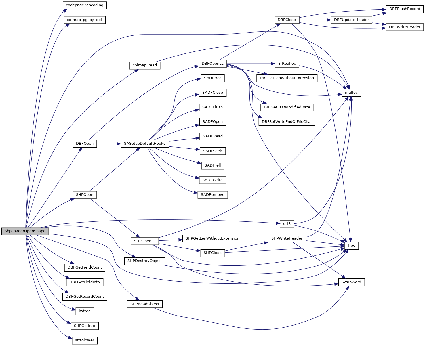
References _, codepage2encoding(), shp_loader_state::col_names, COLLECTIONTYPE, colmap_pg_by_dbf(), colmap_read(), shp_loader_state::column_map, shp_loader_config::column_map_filename, shp_loader_state::config, DBFGetFieldCount(), DBFGetFieldInfo(), DBFGetRecordCount(), DBFOpen(), shp_loader_config::encoding, ENCODING_DEFAULT, shp_loader_state::field_names, shp_loader_config::force_output, FORCE_OUTPUT_2D, FORCE_OUTPUT_3DM, FORCE_OUTPUT_3DZ, FORCE_OUTPUT_4D, shp_loader_config::forceint4, free(), FTDate, FTDouble, FTInteger, FTInvalid, FTLogical, FTString, shp_loader_state::geo_col, shp_loader_state::has_m, shp_loader_state::has_z, shp_loader_state::hDBFHandle, shp_loader_state::hSHPHandle, lwfree(), malloc(), MAXFIELDNAMELEN, shp_loader_state::message, MULTILINETYPE, MULTIPOINTTYPE, MULTIPOLYGONTYPE, shp_loader_config::null_policy, shp_loader_state::num_entities, shp_loader_state::num_fields, shp_loader_state::num_records, tagSHPObject::nVertices, shp_loader_state::pgdims, shp_loader_state::pgfieldtypes, shp_loader_state::pgtype, POINTTYPE, POLICY_NULL_ABORT, shp_loader_state::precisions, DBFInfo::pszCodePage, shp_loader_config::quoteidentifiers, shp_loader_config::readshape, shp_loader_config::shp_file, SHPDestroyObject(), shp_loader_state::shpfiletype, SHPGetInfo(), SHPLOADERERR, SHPLOADERMSGLEN, SHPLOADEROK, SHPLOADERWARN, SHPOpen(), SHPReadObject(), SHPT_ARC, SHPT_ARCM, SHPT_ARCZ, SHPT_MULTIPOINT, SHPT_MULTIPOINTM, SHPT_MULTIPOINTZ, SHPT_POINT, SHPT_POINTM, SHPT_POINTZ, SHPT_POLYGON, SHPT_POLYGONM, SHPT_POLYGONZ, shp_loader_config::simple_geometries, strtolower(), ovdump::type, shp_loader_state::types, utf8(), UTF8_BAD_RESULT, UTF8_GOOD_RESULT, UTF8_NO_RESULT, and shp_loader_state::widths.

Referenced by pgui_action_import(), and validate_remote_loader_columns().

Here is the call graph for this function:
Here is the caller graph for this function: