PostGIS  3.4.0dev-r@@SVN_REVISION@@

◆ lw_dist2d_pt_ptarrayarc()

int lw_dist2d_pt_ptarrayarc ( const POINT2D p,
const POINTARRAY pa,
DISTPTS dl 
)

Search all the arcs of pointarray to see which one is closest to p1 Returns minimum distance between point and arc pointarray.

Definition at line 1160 of file measures.c.

1161 {
1162  uint32_t t;
1163  const POINT2D *A1;
1164  const POINT2D *A2;
1165  const POINT2D *A3;
1166  int twist = dl->twisted;
1167 
1168  LWDEBUG(2, "lw_dist2d_pt_ptarrayarc is called");
1169 
1170  if (pa->npoints % 2 == 0 || pa->npoints < 3)
1171  {
1172  lwerror("lw_dist2d_pt_ptarrayarc called with non-arc input");
1173  return LW_FALSE;
1174  }
1175 
1176  if (dl->mode == DIST_MAX)
1177  {
1178  lwerror("lw_dist2d_pt_ptarrayarc does not currently support DIST_MAX mode");
1179  return LW_FALSE;
1180  }
1181 
1182  A1 = getPoint2d_cp(pa, 0);
1183 
1184  if (!lw_dist2d_pt_pt(p, A1, dl))
1185  return LW_FALSE;
1186 
1187  for (t = 1; t < pa->npoints; t += 2)
1188  {
1189  dl->twisted = twist;
1190  A2 = getPoint2d_cp(pa, t);
1191  A3 = getPoint2d_cp(pa, t + 1);
1192 
1193  if (lw_dist2d_pt_arc(p, A1, A2, A3, dl) == LW_FALSE)
1194  return LW_FALSE;
1195 
1196  if (dl->distance <= dl->tolerance && dl->mode == DIST_MIN)
1197  return LW_TRUE; /*just a check if the answer is already given*/
1198 
1199  A1 = A3;
1200  }
1201 
1202  return LW_TRUE;
1203 }
#define LW_FALSE
Definition: liblwgeom.h:94
#define LW_TRUE
Return types for functions with status returns.
Definition: liblwgeom.h:93
#define LWDEBUG(level, msg)
Definition: lwgeom_log.h:83
void lwerror(const char *fmt,...)
Write a notice out to the error handler.
Definition: lwutil.c:190
static const POINT2D * getPoint2d_cp(const POINTARRAY *pa, uint32_t n)
Returns a POINT2D pointer into the POINTARRAY serialized_ptlist, suitable for reading from.
Definition: lwinline.h:101
int lw_dist2d_pt_arc(const POINT2D *P, const POINT2D *A1, const POINT2D *A2, const POINT2D *A3, DISTPTS *dl)
Definition: measures.c:1513
int lw_dist2d_pt_pt(const POINT2D *thep1, const POINT2D *thep2, DISTPTS *dl)
Compares incoming points and stores the points closest to each other or most far away from each other...
Definition: measures.c:2366
#define DIST_MIN
Definition: measures.h:44
#define DIST_MAX
Definition: measures.h:43
int twisted
Definition: measures.h:55
double tolerance
Definition: measures.h:56
int mode
Definition: measures.h:54
double distance
Definition: measures.h:51
uint32_t npoints
Definition: liblwgeom.h:427

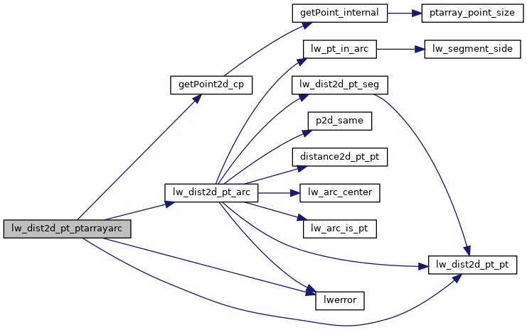
References DIST_MAX, DIST_MIN, DISTPTS::distance, getPoint2d_cp(), lw_dist2d_pt_arc(), lw_dist2d_pt_pt(), LW_FALSE, LW_TRUE, LWDEBUG, lwerror(), DISTPTS::mode, POINTARRAY::npoints, DISTPTS::tolerance, and DISTPTS::twisted.

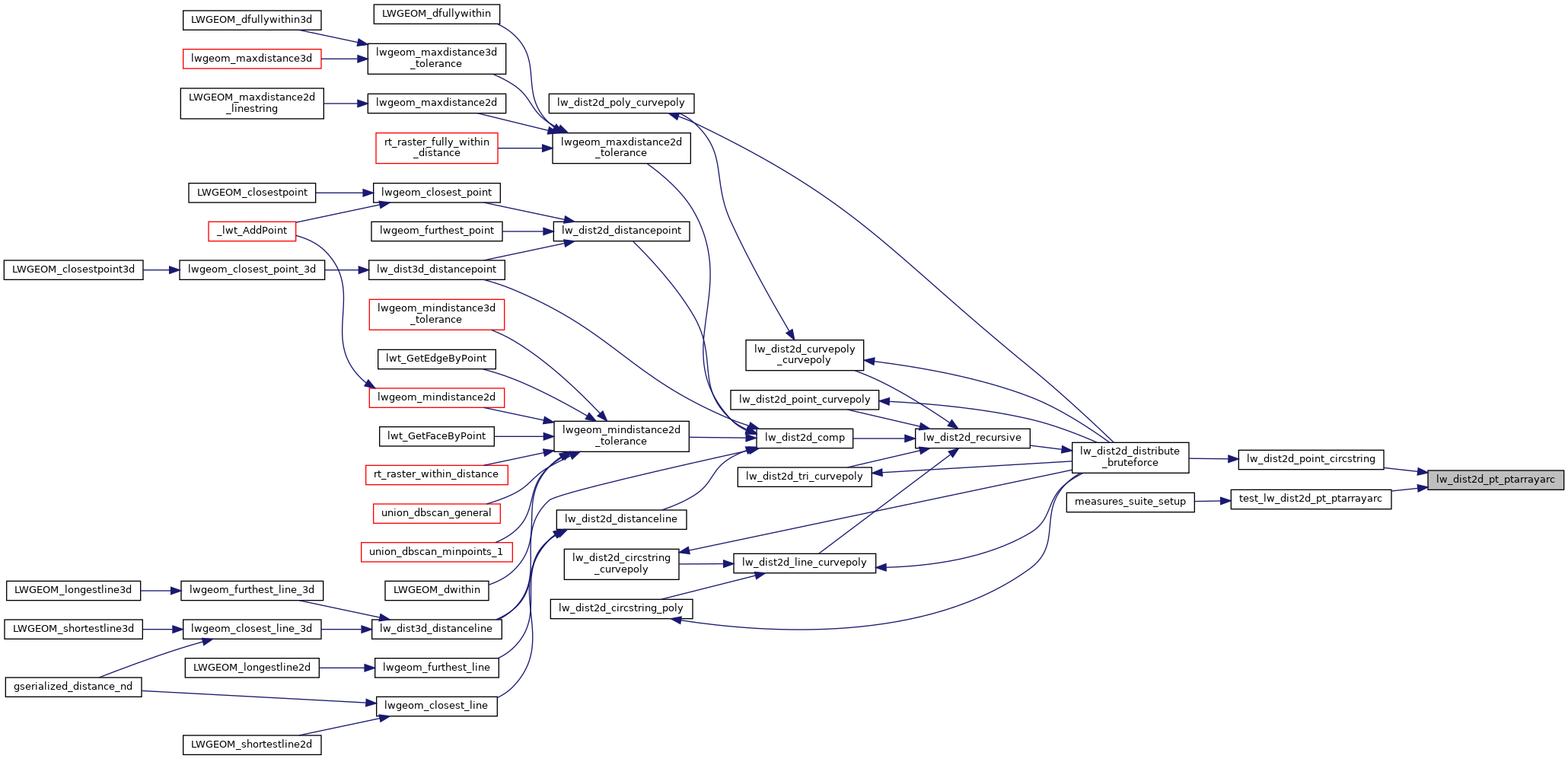
Referenced by lw_dist2d_point_circstring(), and test_lw_dist2d_pt_ptarrayarc().

Here is the call graph for this function:
Here is the caller graph for this function: