PostGIS  3.3.9dev-r@@SVN_REVISION@@

◆ covers()

Datum covers ( PG_FUNCTION_ARGS  )

Definition at line 1952 of file postgis/lwgeom_geos.c.

1953 {
1954  SHARED_GSERIALIZED *shared_geom1 = ToastCacheGetGeometry(fcinfo, 0);
1955  SHARED_GSERIALIZED *shared_geom2 = ToastCacheGetGeometry(fcinfo, 1);
1956  const GSERIALIZED *geom1 = shared_gserialized_get(shared_geom1);
1957  const GSERIALIZED *geom2 = shared_gserialized_get(shared_geom2);
1958  int result;
1959  GBOX box1, box2;
1960  PrepGeomCache *prep_cache;
1961 
1962 
1963  /* A.Covers(Empty) == FALSE */
1964  if ( gserialized_is_empty(geom1) || gserialized_is_empty(geom2) )
1965  PG_RETURN_BOOL(false);
1966 
1967  gserialized_error_if_srid_mismatch(geom1, geom2, __func__);
1968 
1969  /*
1970  * short-circuit 1: if geom2 bounding box is not completely inside
1971  * geom1 bounding box we can return FALSE.
1972  */
1973  if ( gserialized_get_gbox_p(geom1, &box1) &&
1974  gserialized_get_gbox_p(geom2, &box2) )
1975  {
1976  if ( ! gbox_contains_2d(&box1, &box2) )
1977  {
1978  PG_RETURN_BOOL(false);
1979  }
1980  }
1981  /*
1982  * short-circuit 2: if geom2 is a point and geom1 is a polygon
1983  * call the point-in-polygon function.
1984  */
1985  if (is_poly(geom1) && is_point(geom2))
1986  {
1987  SHARED_GSERIALIZED *shared_gpoly = is_poly(geom1) ? shared_geom1 : shared_geom2;
1988  SHARED_GSERIALIZED *shared_gpoint = is_point(geom1) ? shared_geom1 : shared_geom2;
1989  const GSERIALIZED *gpoly = shared_gserialized_get(shared_gpoly);
1990  const GSERIALIZED *gpoint = shared_gserialized_get(shared_gpoint);
1991  RTREE_POLY_CACHE *cache = GetRtreeCache(fcinfo, shared_gpoly);
1992  int retval;
1993 
1994  POSTGIS_DEBUG(3, "Point in Polygon test requested...short-circuiting.");
1995  if (gserialized_get_type(gpoint) == POINTTYPE)
1996  {
1997  LWGEOM* point = lwgeom_from_gserialized(gpoint);
1998  int pip_result = pip_short_circuit(cache, lwgeom_as_lwpoint(point), gpoly);
1999  lwgeom_free(point);
2000 
2001  retval = (pip_result != -1); /* not outside */
2002  }
2003  else if (gserialized_get_type(gpoint) == MULTIPOINTTYPE)
2004  {
2006  uint32_t i;
2007 
2008  retval = LW_TRUE;
2009  for (i = 0; i < mpoint->ngeoms; i++)
2010  {
2011  LWPOINT *pt = mpoint->geoms[i];
2012  if (lwpoint_is_empty(pt)) continue;
2013  if (pip_short_circuit(cache, pt, gpoly) == -1)
2014  {
2015  retval = LW_FALSE;
2016  break;
2017  }
2018  }
2019 
2020  lwmpoint_free(mpoint);
2021  }
2022  else
2023  {
2024  /* Never get here */
2025  elog(ERROR,"Type isn't point or multipoint!");
2026  PG_RETURN_NULL();
2027  }
2028 
2029  PG_RETURN_BOOL(retval);
2030  }
2031  else
2032  {
2033  POSTGIS_DEBUGF(3, "Covers: type1: %d, type2: %d", gserialized_get_type(geom1), gserialized_get_type(geom2));
2034  }
2035 
2036  initGEOS(lwpgnotice, lwgeom_geos_error);
2037 
2038  prep_cache = GetPrepGeomCache(fcinfo, shared_geom1, 0);
2039 
2040  if ( prep_cache && prep_cache->prepared_geom && prep_cache->gcache.argnum == 1 )
2041  {
2042  GEOSGeometry *g1 = POSTGIS2GEOS(geom2);
2043  if (!g1) HANDLE_GEOS_ERROR("First argument geometry could not be converted to GEOS");
2044  result = GEOSPreparedCovers( prep_cache->prepared_geom, g1);
2045  GEOSGeom_destroy(g1);
2046  }
2047  else
2048  {
2049  GEOSGeometry *g1;
2050  GEOSGeometry *g2;
2051 
2052  g1 = POSTGIS2GEOS(geom1);
2053  if (!g1) HANDLE_GEOS_ERROR("First argument geometry could not be converted to GEOS");
2054  g2 = POSTGIS2GEOS(geom2);
2055  if (!g2)
2056  {
2057  GEOSGeom_destroy(g1);
2058  HANDLE_GEOS_ERROR("Second argument geometry could not be converted to GEOS");
2059  }
2060  result = GEOSRelatePattern( g1, g2, "******FF*" );
2061  GEOSGeom_destroy(g1);
2062  GEOSGeom_destroy(g2);
2063  }
2064 
2065  if (result == 2) HANDLE_GEOS_ERROR("GEOSCovers");
2066 
2067  PG_RETURN_BOOL(result);
2068 }
char result[OUT_DOUBLE_BUFFER_SIZE]
Definition: cu_print.c:267
int gbox_contains_2d(const GBOX *g1, const GBOX *g2)
Return LW_TRUE if the first GBOX contains the second on the 2d plane, LW_FALSE otherwise.
Definition: gbox.c:339
void gserialized_error_if_srid_mismatch(const GSERIALIZED *g1, const GSERIALIZED *g2, const char *funcname)
Definition: gserialized.c:403
int gserialized_get_gbox_p(const GSERIALIZED *g, GBOX *gbox)
Read the box from the GSERIALIZED or calculate it if necessary.
Definition: gserialized.c:65
LWGEOM * lwgeom_from_gserialized(const GSERIALIZED *g)
Allocate a new LWGEOM from a GSERIALIZED.
Definition: gserialized.c:239
int gserialized_is_empty(const GSERIALIZED *g)
Check if a GSERIALIZED is empty without deserializing first.
Definition: gserialized.c:152
uint32_t gserialized_get_type(const GSERIALIZED *g)
Extract the geometry type from the serialized form (it hides in the anonymous data area,...
Definition: gserialized.c:89
void lwgeom_geos_error(const char *fmt,...)
#define LW_FALSE
Definition: liblwgeom.h:109
void lwmpoint_free(LWMPOINT *mpt)
Definition: lwmpoint.c:72
LWMPOINT * lwgeom_as_lwmpoint(const LWGEOM *lwgeom)
Definition: lwgeom.c:242
void lwgeom_free(LWGEOM *geom)
Definition: lwgeom.c:1155
#define MULTIPOINTTYPE
Definition: liblwgeom.h:120
#define POINTTYPE
LWTYPE numbers, used internally by PostGIS.
Definition: liblwgeom.h:117
#define LW_TRUE
Return types for functions with status returns.
Definition: liblwgeom.h:108
int lwpoint_is_empty(const LWPOINT *point)
PrepGeomCache * GetPrepGeomCache(FunctionCallInfo fcinfo, SHARED_GSERIALIZED *g1, SHARED_GSERIALIZED *g2)
Given a couple potential geometries and a function call context, return a prepared structure for one ...
RTREE_POLY_CACHE * GetRtreeCache(FunctionCallInfo fcinfo, SHARED_GSERIALIZED *g1)
Checks for a cache hit against the provided geometry and returns a pre-built index structure (RTREE_P...
Definition: lwgeom_rtree.c:432
static LWPOINT * lwgeom_as_lwpoint(const LWGEOM *lwgeom)
Definition: lwinline.h:131
#define HANDLE_GEOS_ERROR(label)
static char is_point(const GSERIALIZED *g)
static int pip_short_circuit(RTREE_POLY_CACHE *poly_cache, LWPOINT *point, const GSERIALIZED *gpoly)
static char is_poly(const GSERIALIZED *g)
GEOSGeometry * POSTGIS2GEOS(const GSERIALIZED *pglwgeom)
uint32_t ngeoms
Definition: liblwgeom.h:553
LWPOINT ** geoms
Definition: liblwgeom.h:548
const GEOSPreparedGeometry * prepared_geom
The tree structure used for fast P-i-P tests by point_in_multipolygon_rtree()
Definition: lwgeom_rtree.h:59

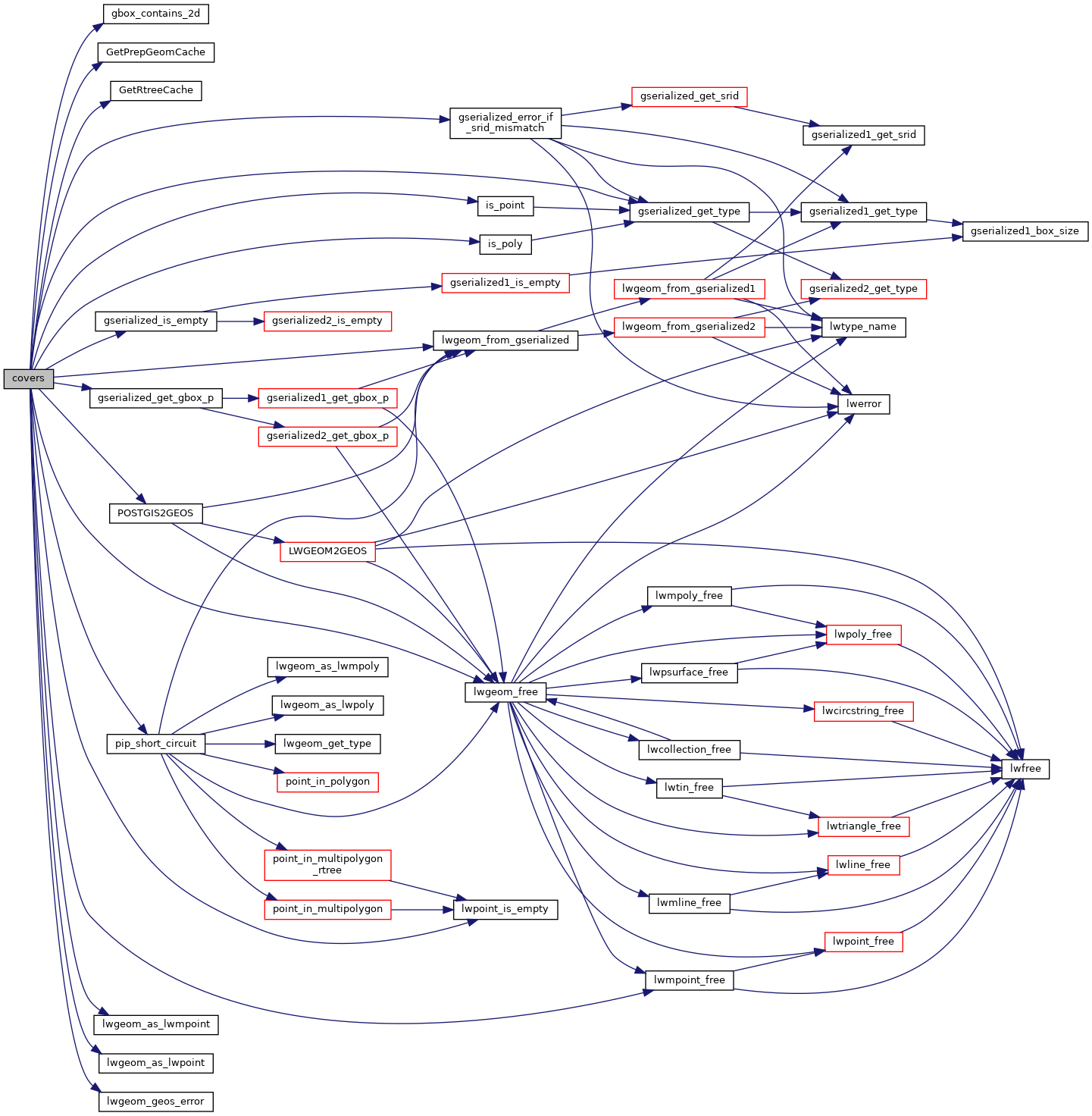
References gbox_contains_2d(), PrepGeomCache::gcache, LWMPOINT::geoms, GetPrepGeomCache(), GetRtreeCache(), gserialized_error_if_srid_mismatch(), gserialized_get_gbox_p(), gserialized_get_type(), gserialized_is_empty(), HANDLE_GEOS_ERROR, is_point(), is_poly(), LW_FALSE, LW_TRUE, lwgeom_as_lwmpoint(), lwgeom_as_lwpoint(), lwgeom_free(), lwgeom_from_gserialized(), lwgeom_geos_error(), lwmpoint_free(), lwpoint_is_empty(), MULTIPOINTTYPE, LWMPOINT::ngeoms, pip_short_circuit(), POINTTYPE, POSTGIS2GEOS(), PrepGeomCache::prepared_geom, and result.

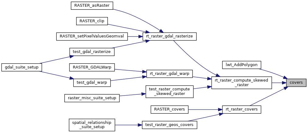
Referenced by lwt_AddPolygon(), rt_raster_compute_skewed_raster(), and rt_raster_covers().

Here is the call graph for this function:
Here is the caller graph for this function: