PostGIS  3.3.9dev-r@@SVN_REVISION@@

◆ edge_calculate_gbox_slow()

int edge_calculate_gbox_slow ( const GEOGRAPHIC_EDGE e,
GBOX gbox 
)

Definition at line 1298 of file lwgeodetic.c.

1299 {
1300  int steps = 1000000;
1301  int i;
1302  double dx, dy, dz;
1303  double distance = sphere_distance(&(e->start), &(e->end));
1304  POINT3D pn, p, start, end;
1305 
1306  /* Edge is zero length, just return the naive box */
1307  if ( FP_IS_ZERO(distance) )
1308  {
1309  LWDEBUG(4, "edge is zero length. returning");
1310  geog2cart(&(e->start), &start);
1311  geog2cart(&(e->end), &end);
1312  gbox_init_point3d(&start, gbox);
1313  gbox_merge_point3d(&end, gbox);
1314  return LW_SUCCESS;
1315  }
1316 
1317  /* Edge is antipodal (one point on each side of the globe),
1318  set the box to contain the whole world and return */
1319  if ( FP_EQUALS(distance, M_PI) )
1320  {
1321  LWDEBUG(4, "edge is antipodal. setting to maximum size box, and returning");
1322  gbox->xmin = gbox->ymin = gbox->zmin = -1.0;
1323  gbox->xmax = gbox->ymax = gbox->zmax = 1.0;
1324  return LW_SUCCESS;
1325  }
1326 
1327  /* Walk along the chord between start and end incrementally,
1328  normalizing at each step. */
1329  geog2cart(&(e->start), &start);
1330  geog2cart(&(e->end), &end);
1331  dx = (end.x - start.x)/steps;
1332  dy = (end.y - start.y)/steps;
1333  dz = (end.z - start.z)/steps;
1334  p = start;
1335  gbox->xmin = gbox->xmax = p.x;
1336  gbox->ymin = gbox->ymax = p.y;
1337  gbox->zmin = gbox->zmax = p.z;
1338  for ( i = 0; i < steps; i++ )
1339  {
1340  p.x += dx;
1341  p.y += dy;
1342  p.z += dz;
1343  pn = p;
1344  normalize(&pn);
1345  gbox_merge_point3d(&pn, gbox);
1346  }
1347  return LW_SUCCESS;
1348 }
int gbox_merge_point3d(const POINT3D *p, GBOX *gbox)
Update the GBOX to be large enough to include itself and the new point.
Definition: gbox.c:228
int gbox_init_point3d(const POINT3D *p, GBOX *gbox)
Initialize a GBOX using the values of the point.
Definition: gbox.c:239
#define LW_SUCCESS
Definition: liblwgeom.h:112
#define FP_EQUALS(A, B)
#define FP_IS_ZERO(A)
void normalize(POINT3D *p)
Normalize to a unit vector.
Definition: lwgeodetic.c:615
double sphere_distance(const GEOGRAPHIC_POINT *s, const GEOGRAPHIC_POINT *e)
Given two points on a unit sphere, calculate their distance apart in radians.
Definition: lwgeodetic.c:896
void geog2cart(const GEOGRAPHIC_POINT *g, POINT3D *p)
Convert spherical coordinates to cartesian coordinates on unit sphere.
Definition: lwgeodetic.c:404
#define LWDEBUG(level, msg)
Definition: lwgeom_log.h:83
static double distance(double x1, double y1, double x2, double y2)
Definition: lwtree.c:1032
double ymax
Definition: liblwgeom.h:372
double zmax
Definition: liblwgeom.h:374
double xmax
Definition: liblwgeom.h:370
double zmin
Definition: liblwgeom.h:373
double ymin
Definition: liblwgeom.h:371
double xmin
Definition: liblwgeom.h:369
GEOGRAPHIC_POINT start
Definition: lwgeodetic.h:64
GEOGRAPHIC_POINT end
Definition: lwgeodetic.h:65
double z
Definition: liblwgeom.h:417
double x
Definition: liblwgeom.h:417
double y
Definition: liblwgeom.h:417

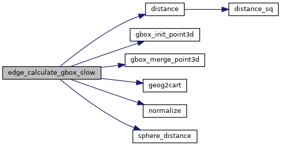
References distance(), GEOGRAPHIC_EDGE::end, FP_EQUALS, FP_IS_ZERO, gbox_init_point3d(), gbox_merge_point3d(), geog2cart(), LW_SUCCESS, LWDEBUG, normalize(), sphere_distance(), GEOGRAPHIC_EDGE::start, POINT3D::x, GBOX::xmax, GBOX::xmin, POINT3D::y, GBOX::ymax, GBOX::ymin, POINT3D::z, GBOX::zmax, and GBOX::zmin.

Here is the call graph for this function: