PostGIS  3.1.6dev-r@@SVN_REVISION@@

◆ interpolate_point4d()

void interpolate_point4d ( const POINT4D A,
const POINT4D B,
POINT4D I,
double  F 
)

Find interpolation point I between point A and point B so that the len(AI) == len(AB)*F and I falls on AB segment.

Example:

F=0.5 : A-—I-—B F=1 : A------—B==I F=0 : A==I------—B F=.2 : A-I----—B

Definition at line 650 of file lwgeom_api.c.

651 {
652 #if PARANOIA_LEVEL > 0
653  if (F < 0 || F > 1) lwerror("interpolate_point4d: invalid F (%g)", F);
654 #endif
655  I->x=A->x+((B->x-A->x)*F);
656  I->y=A->y+((B->y-A->y)*F);
657  I->z=A->z+((B->z-A->z)*F);
658  I->m=A->m+((B->m-A->m)*F);
659 }
void lwerror(const char *fmt,...)
Write a notice out to the error handler.
Definition: lwutil.c:190
double m
Definition: liblwgeom.h:428
double x
Definition: liblwgeom.h:428
double z
Definition: liblwgeom.h:428
double y
Definition: liblwgeom.h:428

References lwerror(), POINT4D::m, POINT4D::x, POINT4D::y, and POINT4D::z.

Referenced by lwline_interpolate_point_3d(), lwline_interpolate_points(), and ptarray_substring().

Here is the call graph for this function:
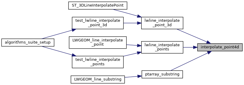
Here is the caller graph for this function: