Name
ST_LineSubstring — Returns the part of a line between two fractional locations.
Synopsis
geometry ST_LineSubstring(geometry a_linestring, float8 startfraction, float8 endfraction);
geography ST_LineSubstring(geography a_linestring, float8 startfraction, float8 endfraction);
Description
Computes the line which is the section of the input line starting and ending at the given fractional locations. The first argument must be a LINESTRING. The second and third arguments are values in the range [0, 1] representing the start and end locations as fractions of line length. The Z and M values are interpolated for added endpoints if present.
If startfraction and endfraction
have the same value this is equivalent
to ST_LineInterpolatePoint.
![[Note]](../images/note.png)
|
|
|
This only works with LINESTRINGs. To use on contiguous MULTILINESTRINGs first join them with ST_LineMerge. |
|
|
|
|
Since release 1.1.1 this function interpolates M and Z values. Prior releases set Z and M to unspecified values. |
Enhanced: 3.4.0 - Support for geography was introduced.
Changed: 2.1.0. Up to 2.0.x this was called ST_Line_Substring.
Availability: 1.1.0, Z and M supported added in 1.1.1
 This function supports 3d and will not drop the z-index.
Examples
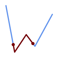
A LineString seen with 1/3 midrange overlaid (0.333, 0.666)
SELECT ST_AsText(ST_LineSubstring( 'LINESTRING (20 180, 50 20, 90 80, 120 40, 180 150)', 0.333, 0.666));
------------------------------------------------------------------------------------------------
LINESTRING (45.17311810399485 45.74337011202746, 50 20, 90 80, 112.97593050157862 49.36542599789519)
If start and end locations are the same, the result is a POINT.
SELECT ST_AsText(ST_LineSubstring( 'LINESTRING(25 50, 100 125, 150 190)', 0.333, 0.333));
------------------------------------------
 POINT(69.2846934853974 94.2846934853974)
A query to cut a LineString into sections of length 100 or shorter.
It uses generate_series() with a CROSS JOIN LATERAL
to produce the equivalent of a FOR loop.
WITH data(id, geom) AS (VALUES
        ( 'A', 'LINESTRING( 0 0, 200 0)'::geometry ),
        ( 'B', 'LINESTRING( 0 100, 350 100)'::geometry ),
        ( 'C', 'LINESTRING( 0 200, 50 200)'::geometry )
    )
SELECT id, i,
       ST_AsText( ST_LineSubstring( geom, startfrac, LEAST( endfrac, 1 )) ) AS geom
FROM (
    SELECT id, geom, ST_Length(geom) len, 100 sublen FROM data
    ) AS d
CROSS JOIN LATERAL (
    SELECT i, (sublen * i) / len AS startfrac,
              (sublen * (i+1)) / len AS endfrac
    FROM generate_series(0, floor( len / sublen )::integer ) AS t(i)
    -- skip last i if line length is exact multiple of sublen
    WHERE (sublen * i) / len <> 1.0
    ) AS d2;

 id | i |            geom
----+---+-----------------------------
 A  | 0 | LINESTRING(0 0,100 0)
 A  | 1 | LINESTRING(100 0,200 0)
 B  | 0 | LINESTRING(0 100,100 100)
 B  | 1 | LINESTRING(100 100,200 100)
 B  | 2 | LINESTRING(200 100,300 100)
 B  | 3 | LINESTRING(300 100,350 100)
 C  | 0 | LINESTRING(0 200,50 200)
Geography implementation measures along a spheroid, geometry along a line
SELECT ST_AsText(ST_LineSubstring( 'LINESTRING(-118.2436 34.0522, -71.0570 42.3611)'::geography, 0.333, 0.666),6) AS geog_sub
 , ST_AsText(ST_LineSubstring('LINESTRING(-118.2436 34.0522, -71.0570 42.3611)'::geometry, 0.333, 0.666),6) AS geom_sub;
---------------------------------------------------------------
geog_sub | LINESTRING(-104.167064 38.854691,-87.674646 41.849854)
geom_sub | LINESTRING(-102.530462 36.819064,-86.817324 39.585927)
See Also
ST_Length, ST_LineExtend, ST_LineInterpolatePoint, ST_LineMerge